Exploring Society: India and Beyond
——————————————
Social Science Textbook for
Grade 8 | Part 2
Notes
———
Chapter 1
To get the best of the notes , read the chapter 1 from your Social Science Textbook for Grade 8 | Part 2.
Then read “Ch 1 World Geography: Some Glimpses Notes” . We have broken the big paragraphs into headings and subheadings for better learning and retention, but reading NCERT is a must.
More Class 8 resources Click here
The Complexity of Mapping the Earth
Earth is an oblate spheroid (slightly flattened at poles). Showing its curved surface on a flat map always causes some distortion.
Maps and Map Projections
Map Projection
• Earth’s curved surface is flattened into a map.
• This always causes distortion.
Types of Projections
• Different projections show different features.
• Some keep shape correct.
• Others keep size correct.
Importance
• Use multiple projections for a fair view.
• Maps show size, shape, location, and distance.
• Latitude and longitude give precise locations.
Why Do Map Projections Distort?
Earth’s curved surface
🡇
Cannot be flattened perfectly
🡇
Every map projection has some distortion (shape or size)
Comparison
| Feature | Shows Correct Shape | Shows Correct Size |
|---|---|---|
| Trade-off | Size gets distorted | Shape gets distorted |
Important Terms
Oblate Spheroid → Earth’s shape — a sphere slightly flattened at the poles.
Map Projection → Method of showing the curved Earth on a flat surface.
Cartographer → A person who prepares maps.
The Blue of the Blue Planet, the Oceans
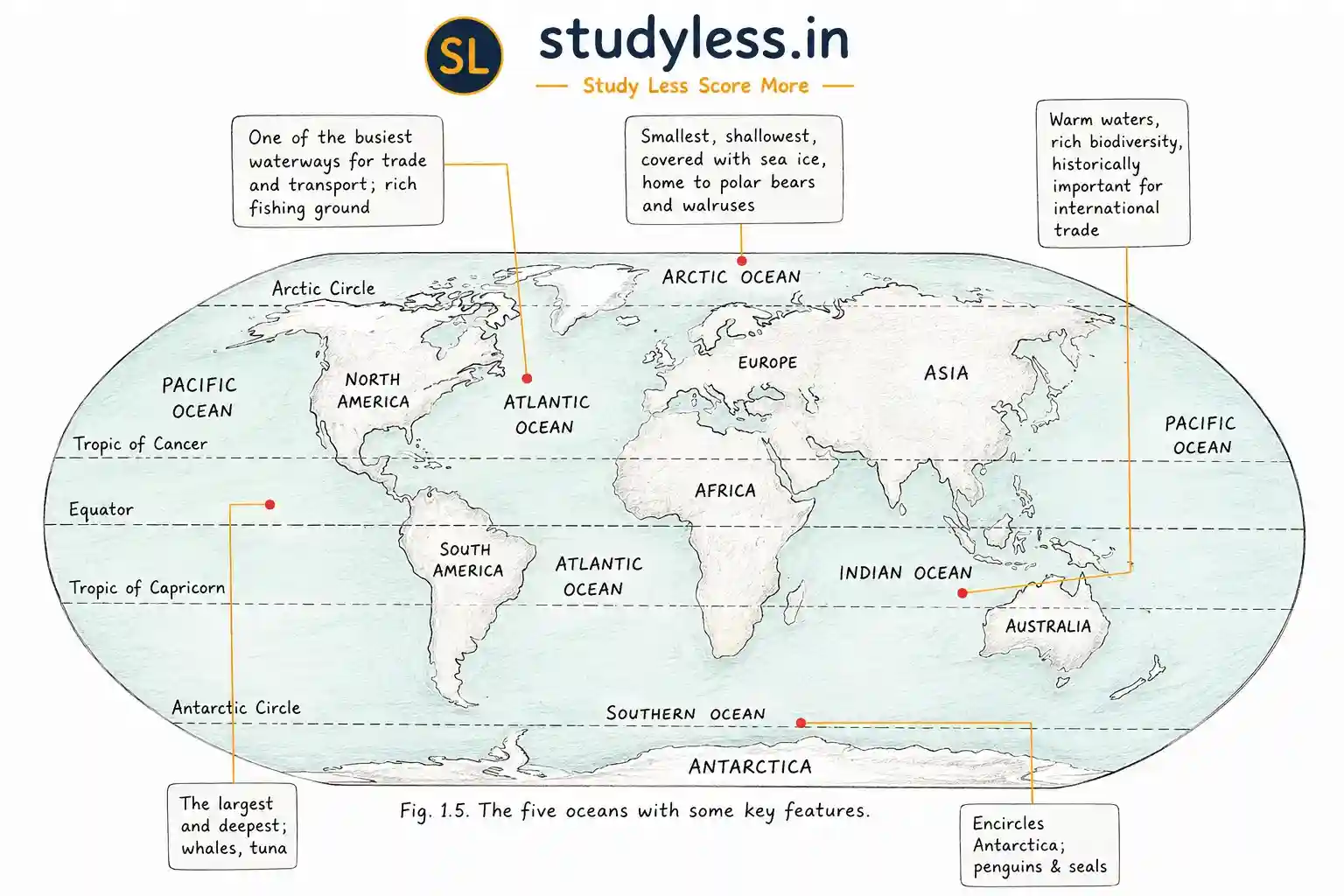
The ocean is a vast body of saltwater covering about 71% of Earth’s surface, holding 97% of Earth’s water. It supports life and regulates climate.
Oceans support life —
from tiny plankton to giant blue whales.
Oceans help regulate climate by:
• Absorbing heat
• Slowly releasing heat
• Adding moisture to air → forms clouds and rainfall
Ocean floor is not flat —
it has mountains, valleys, and plains, similar to land.
Important Terms
Blue Planet → Nickname for Earth, given by astronauts because its vast oceans make it appear blue from space.
Plankton → Tiny organisms living in the ocean.
The oceans
Ocean currents
Ocean currents are like giant rivers flowing through the ocean, moving warm or cold water and affecting the climate of coastal areas.
Classification of Ocean Currents
Warm Currents — bring warm water from equator toward poles
Cold Currents — bring cold water from poles toward equator
Currents affect the climate of coastal areas.
Example: Gulf Stream
• Flows north from near the Equator through the Atlantic Ocean towards Western Europe.
• Carries warm water.
• Makes places like the United Kingdom warmer than other places at the same latitude.
Warm Ocean Current
🡇
Transfers heat
🡇
Warmer coastal regions
🡇
Influences climate
Important Terms
Ocean Current → A large stream of moving ocean water.
Gulf Stream → A warm ocean current flowing from the Equator through the Atlantic Ocean towards Western Europe.
Ocean trenches
Ocean trenches are deep, V-shaped depressions on the seafloor.
• No light reaches trenches → plants cannot use photosynthesis.
• Organisms use energy from chemicals in water to produce food.
The Mariana Trench(over 2,000 metres deeper)
• Deepest Trench
• No sunlight.
• Extreme conditions
• Unique life survives
• Deepest section = Challenger Deep → reaches over 11,000 metres below sea level.
Conditions in the Mariana Trench:
• Near-freezing temperatures
• High pressure
• Complete darkness
The Great Barrier Reef
A reef is a ridge near the ocean surface, formed naturally or artificially.
• Coral reefs are highly diverse ecosystems
• Example:
• Great Barrier Reef, Australia.
Coral Reefs
What is a Reef
• Ridge near the ocean surface.
• Made of rock or corals.
Importance
• Called the rainforests of the sea.
• Home to about ¼ of ocean species.
• Provide food and shelter.
Threats
• Overfishing
• Pollution
• Climate change
Overfishing, pollution, climate change
🡇
Threats to coral reefs
🡇
Need for conservation
Great Barrier Reef
• Location: Australia’s northeastern coast.
• Length: 2,000 km
• Area : 350,000 square kilometres.
• Complex, interconnected habitat with:
Thousands of species of fish + sea animals
Hundreds of species of coral
• A UNESCO World Heritage Site.
Coral Bleaching
• Coral bleaching = death of coral, causing habitat loss for sea animals.
• Caused by changes in the chemical composition of ocean waters.
• Largely caused by human actions.
Important Terms
Coral → Tiny sea animal that can build natural reefs.
Rainforests of the Sea → Nickname for coral reefs due to their rich biodiversity.
UNESCO World Heritage Site → Recognition given to places of outstanding global value.
Smaller water bodies and waterways
Sea-related formations Classification
| Type | Description | Example |
|---|---|---|
| Sea | Large, partly enclosed saltwater area connected to an ocean | Arabian Sea |
| Gulf | Large inlet of the sea deeply cutting into land | Persian Gulf |
| Bay | Smaller, broad inlet of the sea | Bay of Bengal |
| Strait | Narrow channel joining two seas or oceans | Strait of Malacca |
| Canal | Man-made channel connecting water bodies | Suez Canal |
Trade
• Support trade and transport.
• Persian Gulf links India and Europe.
Bays
• Provide safe natural harbours.
• Protect ports from strong ocean winds
Suez Canal
• Man-made canal (opened 1869).
• Connects the Red Sea and Mediterranean Sea.
• Shortens the sea route from the Indian Ocean to Europe.
The Continents: Variety on Land
World landforms include:
- Mountains
- Plateaus
- Plains
Asia
Roof of the world — the Tibetan Plateau
The Tibetan Plateau is the highest and largest plateau on Earth, formed by tectonic collision, and plays a major role in Asia’s climate and river systems.
Tibetan Plateau
• Located north of the Himalayan Range.
• Highest and largest plateau on Earth.
• Formed due to collision between the Indo-Australian and Eurasian tectonic plates.
• Same collision also formed the Himalayan mountain range.
Features Tibetan Plateau
• About 2,500 km east–west.
• About 1,000 km north–south.
• Average height > 4,500 m.
Importance Tibetan Plateau
• Influences Asia’s climate.
• Source of the Indus, Brahmaputra, and Yangtze rivers.
• Called the Third Pole.
• Largest freshwater reserve outside the polar regions.
Climate Change And Tibetan Plateau
• Increased snow-melt.
• Expands old lakes.
• Forms new lakes.
Important Terms
Plateau → Elevated flat land.
Tectonic Plates → Large plates of Earth’s crust whose movement and collision shape landforms.
Third Pole → Nickname for the Tibetan Plateau due to its large freshwater reserves.
Gobi Desert in the ‘Land of the Eternal Blue Sky
Deserts are large, extremely dry areas with low precipitation. (< 25 cm/year)
The Gobi Desert in Mongolia is a major desert of Asia, in the ‘Land of the Eternal Blue Sky’.
Deserts (General)
• Found on every continent.
• Cover about one-fifth of the Earth’s land area.
• One billion people live in deserts.
Gobi Desert
• Located in Mongolia (part of the desert is in north China).
• Mongolia called the ‘Land of the Eternal Blue Sky’:
➢ About 8 to 9 months of sunny weather.
➢ Winter temperatures can drop to minus 30°C.
• Climate: harsh; vegetation: sparse.
• Herds migrate seasonally to access pastures.
• Pastures supported by underground water supplies.
• Human life: Nomadic herding dependent on:
➢ seasonal migration
➢ underground water.
The Eurasian Steppes
The Eurasian Steppes are a vast grassland stretching across Asia, acting as a global carbon sink and supporting migratory birds.
• Spread over 8,000 km from west to east.
• The Steppes are a global carbon sink:
➢Absorbs carbon from the air.
➢Stores it underground.
➢Helps reduce greenhouse effects over time.
• Steppes and nearby water bodies serve as resting spots for migratory birds, e.g., the Siberian crane.
Important Terms
Steppe → Temperate grassland.
Carbon Sink → A natural area that absorbs and stores more carbon than it releases.
The Urals
The Ural Mountains are an ancient range forming the natural boundary between Europe and Asia, rich in minerals and diverse ecosystems.
Physical features: Ural Mountains
• Ancient mountain range.
• Stretches about 2,500 km from the Arctic Ocean to the border of Kazakhstan.
• Forms a natural boundary between Europe and Asia.
• Notable for: rugged slopes, caves, valleys, and forests.
• Rich in mineral resources:
➢ Oil and natural gas
➢ Iron ore
➢ Copper
➢ Zinc
➢ Platinum
➢ Gold
➢ Coal
• Support diverse ecosystems:
➢ Coniferous taiga forests — dominate western and eastern parts.
➢ Deciduous forests — prevail in the south.
• Habitats for animals:
➢ brown bears,
➢ wolves,
➢ lynx,
➢ elk,
➢ reindeer,
➢ sable.
• Varied landscapes:
➢ Northern tundra and swamps
➢ Fertile southern farmland
Important Terms
Taiga → Coniferous forest found in cold climate regions.
Tundra → Treeless frozen plain.
Europe
Plains & Valleys (General Concept)
Plains are vast flatlands formed by sediment deposition;
valleys are carved by rivers. Both sustain agriculture and biodiversity.
Plains:
• Vast flatlands formed by sediment deposition.
• Known for fertile soils supporting farming, trade, and dense populations.
Valleys:
• Carved by rivers.
• Provide fertile soil, water, and transport routes.
• Nurtured some of the world’s earliest civilizations.
Together, plains and river valleys sustain agriculture and foster biodiversity.
The European Plain
Features
• One of the largest plains.
• Low-lying with gentle hills.
• Wide river valleys.
• Fertile soil.
Importance
• Major farming region.
• Main crops:
➢ Wheat
➢ Barley
➢ Rye
➢ Potatoes
• Rivers support trade and transport.
• Rich in coal, oil, and natural gas.
Cities
• Flat land + Favorable climate supported cities like:
➢ Moscow
➢ Berlin
➢ Paris
➢ Amsterdam
➢ Warsaw
Historical & Present Role
• Site of many battles.
• Today, key to Europe’s agriculture and economy.
The Alps
• Crescent-shaped mountain range.
• Forms a natural barrier.
• Highest peak: Mont Blanc.
Vegetation & Wildlife
• Oak and beech → lower slopes.
• Spruce and pine → higher slopes.
• Alpine flowers → high mountains.
• Wildlife: ibex, chamois, marmots, eagles, lynxes, wolves, bears.
Importance
• Source of the Rhine and Danube rivers.
• Provides drinking water, irrigation, and hydroelectric power.
• Rich in iron, copper, lead, rock salt, graphite, gypsum, and magnesite.
• Known for forests, fertile land, skiing, and hiking.
Important Terms
Plain → Vast flatland formed by sediment deposition.
Valley → Low area carved by rivers, providing fertile soil and transport routes.
Edelweiss → Alpine flower found in the high mountains of the Alps.
Africa
Africa has varied landforms including the Sahara Desert, the Savannah grassland, and the Nile River — the world’s longest river.
Major Physical Feature
1. Sahara Desert
Features
• Largest hot desert.
• Temperature: 30°C–46°C.
• Rainfall: below 25 cm.
• Very little vegetation.
People
• Home to nomadic tribes.
• Rear sheep, goats, and camels.
• Depend on trade.
Importance
• Ancient trade routes
• Carried gold, salt, and ideas.
2. Savannah
Features
• Tropical grassland.
• Open grasslands with scattered trees.
• Lies between rainforests and deserts.
• Largest savannahs are in Africa.
Climate &
Wildlife
• Wet and dry seasons.
• Home to elephants, lions, zebras, and giraffes.
• Animals depend on grasses and waterholes.
Threats
• Farming
• Deforestation
• Climate change
Environmental Issues
Farming, deforestation, climate change
🡇
Threat to Savannah ecosystem balance
Important Terms
Savannah → Tropical grassland with scattered trees.
Nomadic Tribes → Communities that move from place to place, often herding livestock.
South America
South America’s key features include the Andes Mountains (largest range in the continent), the Amazon River, and the Atacama Desert.
Major Physical Feature
1. Andes Mountains
Features
• On the west coast of South America.
• Largest mountain range in the continent.
• Includes Mount Aconcagua and Uyuni Salt Flats.
Importance
• Major source of freshwater.
• Feeds the Amazon River.
• Rich in biodiversity.
• Many unique species.
Conservation & Resources
• Only about ¼ of original flora and fauna remains.
• Rich in copper, zinc, silver, and lithium.
2. Atacama Desert (Chile)
• One of the driest places on Earth.
• Stretches about 1,000 km.
• Temperature varies:
➢ 40°C during the day.
➢ 5°C at night.
Important Terms
Salt Flat → Flat land covered with salt.
Conservation Hotspot → Area needing protection of biodiversity.
North America
North America’s key features include the Colorado Plateau, Rocky Mountains, Appalachian Mountains, and the Great Lakes.
Major Physical Feature
1. The Colorado Plateau
Features
• Large highland in the southwestern USA.
• Covers over 3,30,000 km².
• Includes the Grand Canyon.
• Made mainly of sedimentary rocks.
Formation
• Raised by tectonic forces.
• Shaped by erosion.
• Formed deep canyons and red rock landscapes.
Importance
• Rich in coal, oil, natural gas, uranium, and copper.
• Supports coniferous and deciduous forests.
• Important for tourism and mineral resources.
• Grand Canyon attracts about 5 million visitors annually.
2. Rocky Mountains
Features
• Stretch over 4,800 km.
• Rich in copper, gold, and silver.
Importance
• Support mining, hydropower, tourism, and agriculture.
Indigenous Communities
• Home to Native Americans.
• Depended on rivers, forests, and wildlife.
• Considered the mountains sacred.
• Many now live on reservations.
3. Appalachian Mountains
Features
• Among the oldest mountain ranges.
• Fertile valleys and rich wildlife.
Indigenous Communities
• Used natural travel routes.
• Mountains hold spiritual importance.
Importance
• Rich in coal, timber, and natural gas.
• Growing tourism and renewable energy sectors.
4. Appalachian Mountains
Features
• Among the oldest mountain ranges.
• Fertile valleys and rich wildlife.
Indigenous Communities
• Used natural travel routes.
• Mountains hold spiritual importance.
Importance
• Rich in coal, timber, and natural gas.
• Tourism and renewable energy sectors.
5. Great Lakes
Features
• Chain of five freshwater lakes.
• Important shipping route.
Importance
• Supports trade and industry.
• Provides drinking water.
• Habitat for diverse wildlife.
Challenges
• Chemical pollution in lake sediments.
• Water polluted by farm run-off and industrial waste.
Agricultural run-off and industrial processes
🡇
Water contamination in the Great Lakes
🡇
Chemical contamination of lake sediments
The Australian Continent
A large part of Australia is desert, known as the Great Australian Desert, home to unique wildlife and the indigenous Spinifex people.
Major Physical Feature
1. Great Australian Desert
Features
• Much of Australia is desert.
• Includes the Great Victoria Desert.
Wildlife
• Animals: reptiles, skinks, wallabies, bilbies, camels.
• Predators: dingoes, lizards, cats, foxes, snakes.
• Rare species: sandhill dunnart, marsupial mole, mallee fowl.
Indigenous People
• Home to the Spinifex people.
• Lived here for over 25,000 years.
• Culture is preserved by younger generations.
Importance
• Popular for tourism.
• Famous for unique landscapes and wildlife.
Important definitions from the textbook
1. Cartographer: Person who draws or produces maps
2. Oblate spheroid: A nearly spherical shape that bulges at the equator and is slightly flattened at the poles due to its rotation
3. Plankton: Microscopic organisms that have chlorophyll and use sunlight and carbon dioxide to make food.
4. Tectonic: Geological forces related to the movement of the Earth’s crust
5. Steppe: A large area of flat unfrosted grassland, that has a temperate climate with hot summers and cold winters, and moderate rainfall that is often seasonal.
6. Water towers: Mountains are called water towers because they are at a height, and provide freshwater through melting snow and glaciers.
7. Tundra: A tundra is a treeless, cold plain where the soil stays frozen most of the time. This frozen soil, called permafrost, acts like a giant freezer, trapping greenhouse gases like carbon dioxide and methane. As global warming causes the planet to heat up, the permafrost melts, releasing these stored gases and speeding up climate change.
8. Swamp: Land that is always wet and partly covered with water
9. Salt flat: Areas of flat land covered with a layer of salt.
10. Conservation hotspot: An area where efforts are made to save the native flora and fauna lost generally due to human activities.
11. Rainforest: An area of tall, mostly evergreen trees that receives a high amount of rainfall.
12. Fast fashion: Replication of trendy clothing fast and at low costs, generally by producing in countries where labour is paid low wages. The clothing is very quickly discarded when the fashion trends change.