
“Ch 1 Oceans And Life Notes Class 9 “ is strictly based on:
Understanding Society: India And Beyond
Social Science Textbook
Grade 9| Part 2
Ocean Relief
Ocean Floor Landforms
● Mountains ● Valleys ● Plains ● Trenches ● Ridges
Collectively called submarine relief or Oceanic relief
⁘⁘ Mariana Trench
●●●● Pacific Ocean
●●●● Deepest place on Earth
⁘⁘ Mid-Ocean Ridge
●●●● Hidden beneath the ocean
●●●● World’s longest mountain range
●●●●●▸Mauna Kea
●●●●●●◗ Hawai’i
●●●●●●◗ Underwater mountain
●●●●●●◗ Taller than Mount Everest

Important submarine relief features
⁘ Continental Shelf [Imp. zone for resources ]
●●●● Submerged, shallow edge of a continent
●●●● Extends under the ocean
●●●●●▸ Rich in marine life
●●●●●▸ Rich in resources
●●●●●●●●◗ Oil
●●●●●●●●◗ Gas
⁘ Continental Slope
●●●● Beyond Continental shelf
●●●● Steep slope
●●●● Marks the true edge of a continent
Continent ➜ shelf (shallow) ➜ slope (steep) ➜ deep ocean
⁘ Abyssal Plain
●●●● Deep ocean floor
●●●● Vast, flat, deep
●●●●●▸ Main flat expanse of the ocean floor
⁘Mid-Ocean Ridge
●●●● Immense mountain range
●●●● Formed by volcanic activity
●●●●● ▸ Volcanic-origin ridge
⁘ Ocean Trenches
●●●● Location: Ocean floor
●●●● Deepest parts of the ocean
Abyssal Plain [Flat ]
Mid-Ocean Ridge [ Raised ]
Ocean Trenches [Sunken ]
| Seamount | Guyot |
| Underwater mountain | Formed from Seamount |
| volcanic origin | Flat-topped mountain |
| Rises from ocean floor | Summit eroded, then submerged |
Volcanic activity ➜ seamount ➜ wave action ➜ summit flattened
➜ later submerged ➜ Guyot
Movement of Ocean Water: Waves, Tides, and Currents
◉ Ocean water is constantly in motion
⁘⁘⁘⁘ ⁘ Three movements
●●●●●●●●● Waves
●●●●●●●●● Tides
●●●●●●●●● Currents
⁘⁘⁘⁘ ⁘ Roles
●●●●●●●●● Shape Earth’s surface
●●●●●●●●● Support marine life
●●●●●●●●● Aid fishing and travel
●●●●●●●●● Influence climate
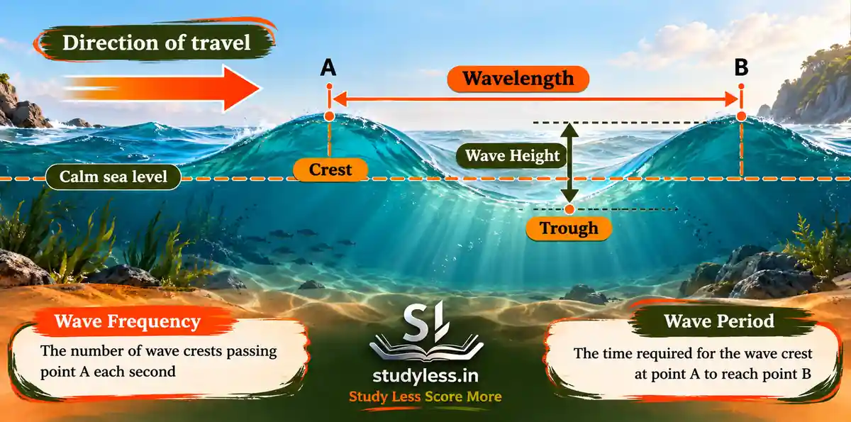
Waves
●⁘ Wave = surface of ocean rises and falls alternately
●⁘ Cause: Winds blowing across water
●●●▸Function:
●●●●●◗ Carry energy across oceans
●●●●●◗ Over long distances
●⁘ Parts
●●●▸Crest = high peak
●●●▸Trough = lower valley
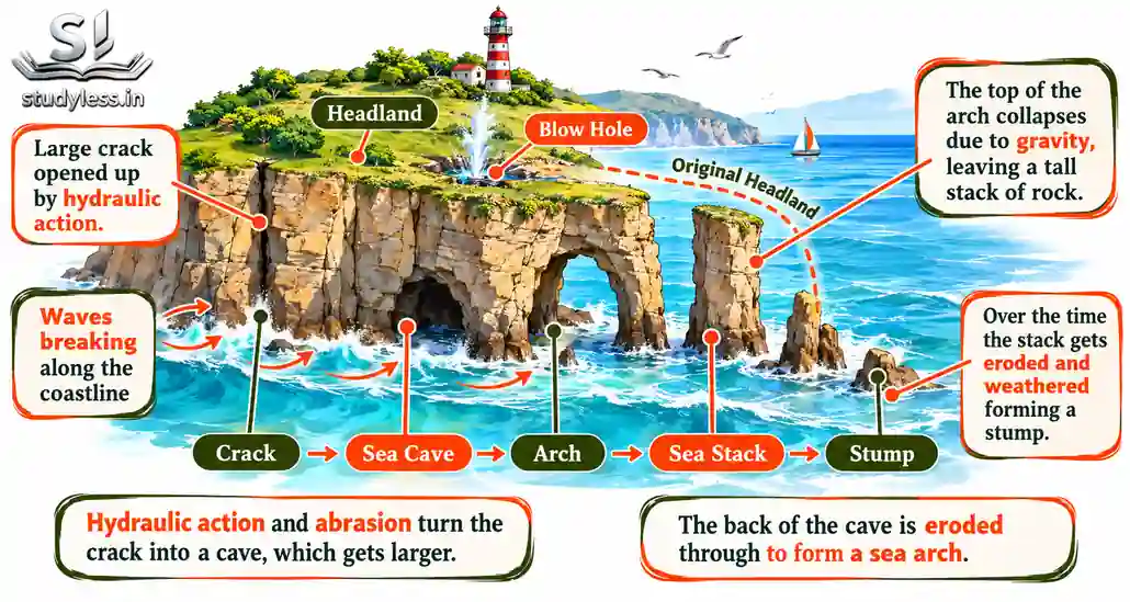
●⁘ Coastal Architects
●●●●● Waves shape shoreline by:
●●●●●●▸Erosion
●●●●●●▸Sediment transport
●●●●●●●◗ Erosional Features
●●●●●●●●●● Sea cracks ● Caves ● Arches ● Sea stacks ● Stumps
Headland ➜ sea cracks ➜ caves ➜ arches ➜ sea stacks ➜ stumps
Storm Waves
◉ Storm → strong winds → huge waves
●●●●● causes coastal damage
Tsunami
● Giant waves
● Mainly caused by underwater earthquakes
●⁘ Feature
●●▸Extremely destructive
●●▸Run-up height
●●●◗ Maximum vertical height above sea level on reaching shore
●●●◗ Up to 30 metres or more
● Most destructive wave type
Tides
● Tides = rhythmic rise and fall of ocean water
● Occur twice a day
| Type | Also called | Water level |
| High tide | Flood tide | Highest; covers much of shore |
| Low tide | Ebb tide | Lowest; moves away from shore |
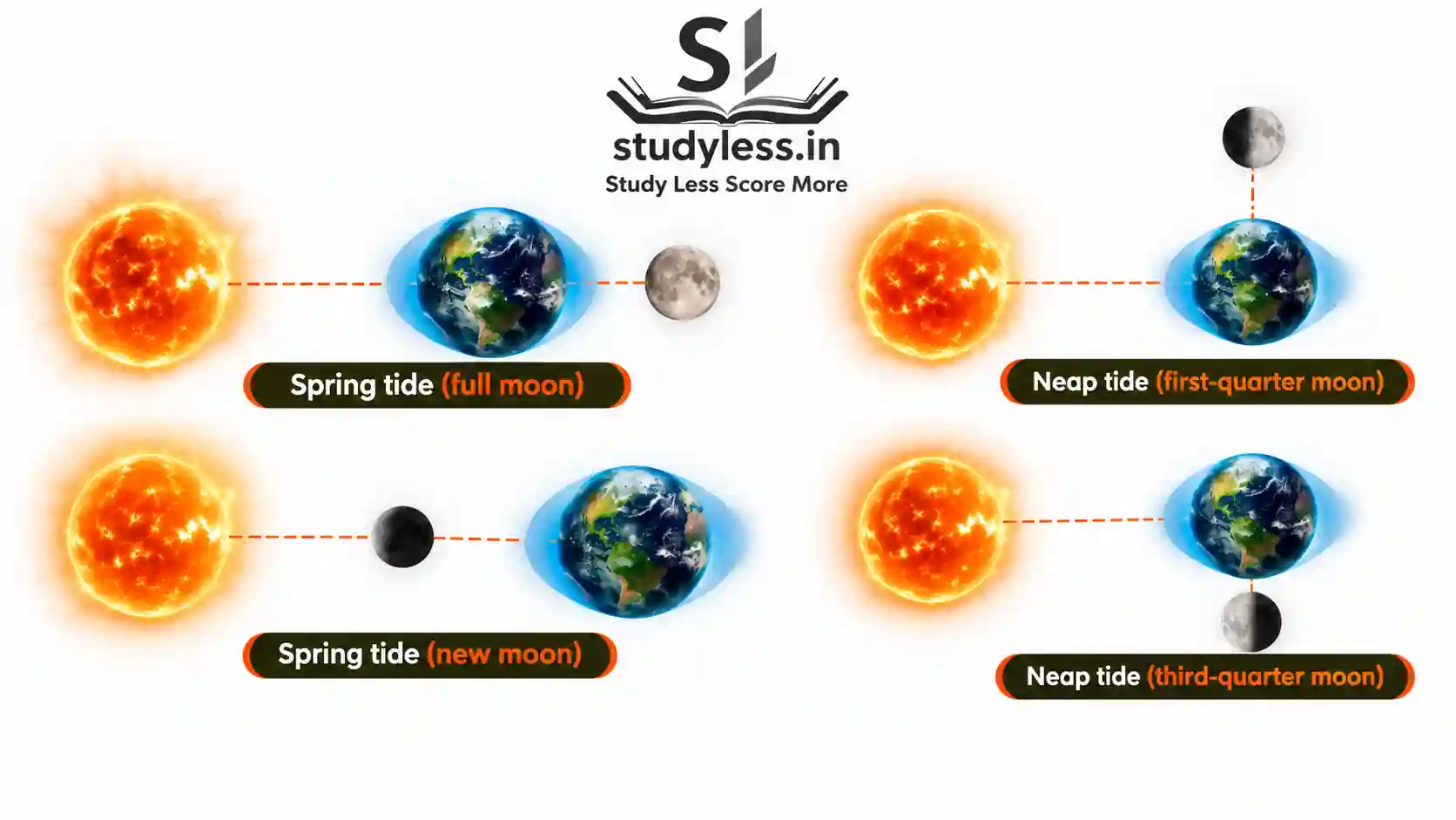
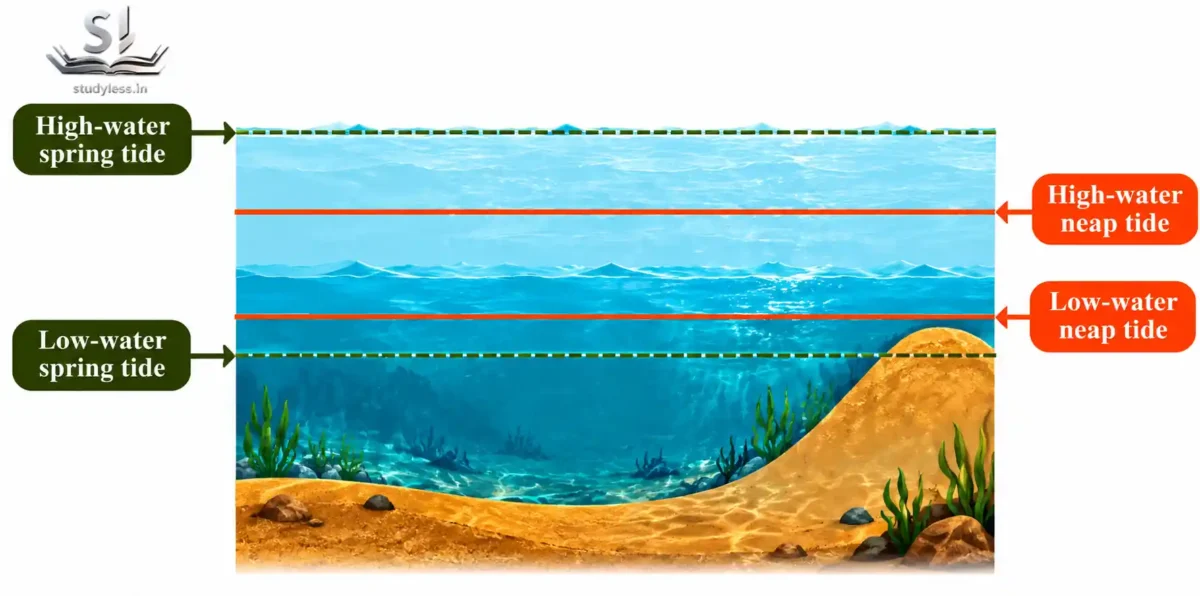
Spring Tides
● Sun–Earth–Moon in a straight line
● On full moon and new moon days
●⁘ Feature:
●●▸Combined gravitational pull of Sun and Moon
●●▸Sometimes very high tides
●●▸Sometimes very Low tides
●●▸Water bulges on opposite sides of Earth
Sun–Earth–Moon aligned ➜ combined gravitational pull ➜ spring tides
Neap Tides
● Moon in first-quarter and third-quarter phases
●⁘ Feature:
●●●▸ Sun and Moon pull in different directions
●●●▸ Smaller difference between high and low tide
●●●▸ Weakest tidal range
Quarter Moon ➜ pulls in different directions ➜ smaller high–low difference
➜ neap tides
| Feature | Spring tide | Neap tide |
| Alignment | Straight line | Different directions |
| Moon phase | Full/new | First / third quarter |
| Tidal range | Unusually high and low | Smaller |
Importance of Tides
● Navigation
●⁍ High tide
●●●▸Raises water near shore
●●●▸Ships enter harbours easily
●⁍ Tidal range in some ports = 4–5 metres
●⁍ Before berthing, ship checks:
●●●▸Water depth
●●●▸Tidal range
● Gulf of Khambhat
●⁍ Coastal area
●⁍ Tidal range about 12 metres (Extreme)
● Singapore Strait
●⁍ Sea channel
●⁍ Shallow areas
●⁍ VLCCs (Very Large Crude Carriers) wait for hours
●⁍ Transit only at high tide
Shallow channel ➜ insufficient depth ➜ VLCC waits ➜ high tide ➜ safe transit.
Tidal Currents
= Strong currents generated by tidal change ➜ large water volumes flow in and out of coasts
●●● 5 to 6 knots or about 9 to11 km/h
Fishing
● High tide → fish move closer to shore
● Better catch for fishing communities
Energy
● Rise and fall of tidal water → electricity
Major tidal energy site in India
●● Gulf of Kutch
●● Gulf of Khambhat
●●●⁍ 12 m tidal range
●● Sundarbans
●●●⁍ Potential for tidal power
Coriolis Force
● Force caused by Earth’s rotation
● Deflects any free-moving object from its straight path
●●⁍ Direction of deflection
●●●●▸Northern Hemisphere → right
●●●●▸Southern Hemisphere → left
● Coriolis force bends the path of ocean currents.
Ocean Currents
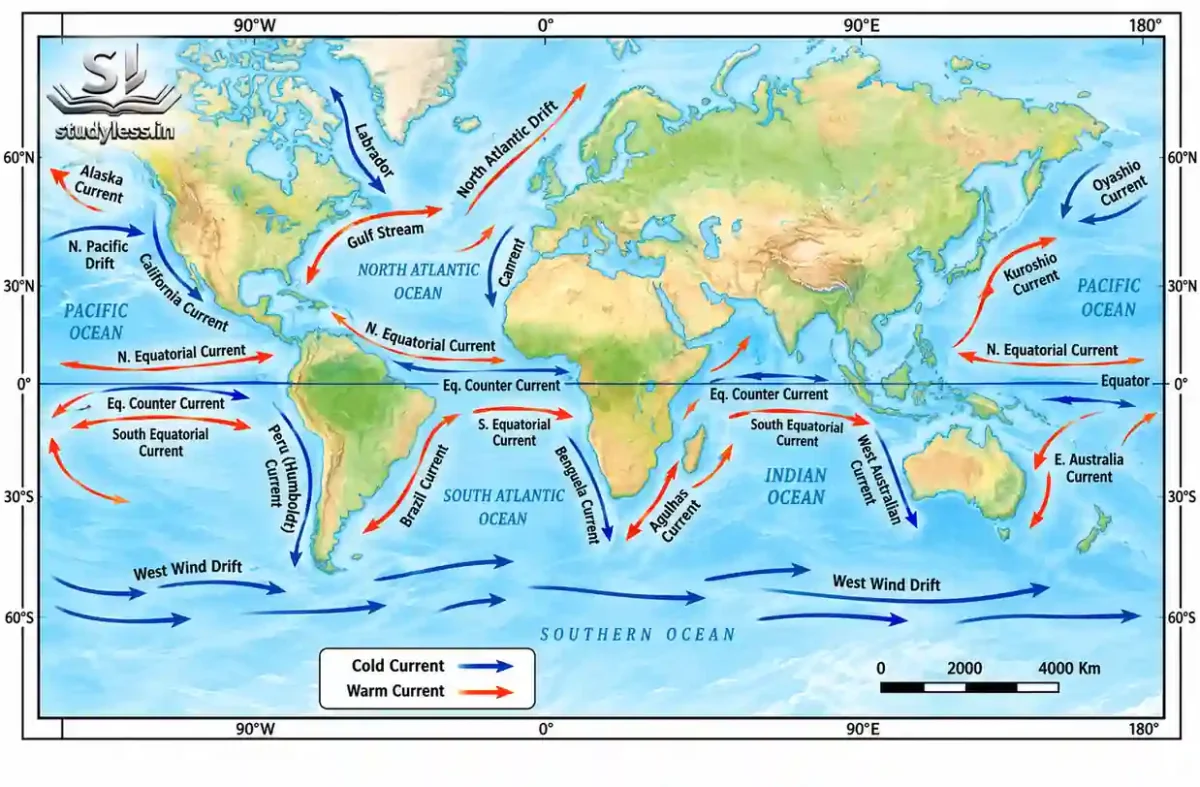
● Ocean currents = continuous streams of water
●⁍ Flow across the ocean surface
●●▸In definite directions
● Causes of Ocean currents
●⁍ Winds
●⁍ Earth’s rotation (Coriolis force)
●⁍ Differences in temperature
●⁍ Differences in salinity
●⁍ Shape of continents
●⁍ Shape of ocean basins
Types of Ocean Currents
“Based on direction from which water flows”
- Warm Current
● Flows from warmer regions
● Shown in red on maps - Cold Current
● Flows from colder regions
● Shown in blue on maps
Origin of water decides whether a current is warm or cold
Examples – Ocean Currents
● Gulf Stream
●⁍ Warm current
●⁍ Originates in Gulf of Mexico, Atlantic Ocean
●●▸Feature:
●●●◗ Keeps Norwegian waters relatively warm
●●●◗ This prevents sea ice formation
●●●●●⁃ Shows how a warm current offsets high-latitude cold
Gulf of Mexico ➜ Gulf Stream (warm) ➜ Norway ➜ waters stay warm
➜ little sea ice at 60°–70°
● Labrador Current
●⁍ Cold current
●⁍ Flows along east coast of Canada
●●▸Feature:
●●●◗ Carries freezing water
●●●◗ Supports sea ice formation
●●●◗ Supports icebergs
●●●◗ Even at lower latitudes = High temperature
Labrador Current (cold) ➜ freezing water along Canada’s east coast → sea ice and icebergs
Cyclones and Tsunamis-Early Warning Systems
Cyclones and Tsunamis are sudden natural hazards in oceans and seas
Cyclone
● In Oceans and seas
● Large rotating storm
● Sudden hazard for coastal areas
Tsunami
● In Oceans and seas
● Giant waves
● Caused by earthquakes
● Sudden hazard for coastal areas
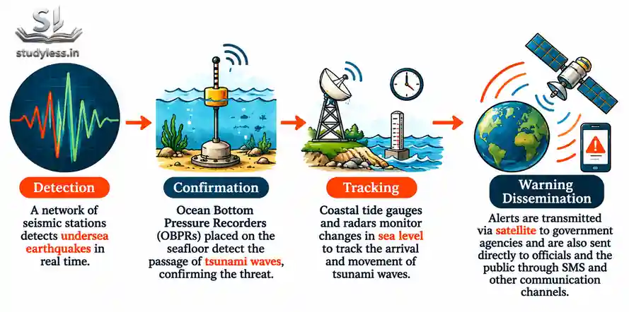
Early Warning Systems
● Giant alarm systems for coastal areas
●●⁍ Functions
●●●●▸Detect cyclones and tsunamis
●●●●▸Predict disasters
●●●●▸Issue timely warnings
●●⁍ Purpose
●●●●▸People evacuate
●●●●▸People stay safe
Detection ➜ prediction ➜ timely warning ➜ evacuation ➜ lives saved
India’s Warning Services
● Services
●●⁍ Cyclone Warning Services
●●⁍ Marine Weather Services
● Coverage
●●⁍ Eastern coast
●●⁍ Western coast
● Advanced technologies predict cyclones at an early stage

Government Initiatives
● National Cyclone Risk Mitigation Project (NCRMP)
●●⁍ Launched by Government of India
●●⁍ Focus: cyclone-prone States and Union Territories
●●●▸Feature:
●●●●●▸Builds cyclone shelters
●●●●●▸Strengthens warning systems
●●●●●▸Improves emergency response
●●●●●▸Includes Decision Support System (DSS)
●●●●●●●●⁃ For disaster management authorities
● Storm Surge Early Warning System (SSEWS)
●●⁍ Location: Indian coasts
●●⁍ Set up by INCOIS with IMD
●●●●▸Feature:
●●●●●●⁃ Forecasts cyclone-induced storm surges
●●●●●●⁃ Forecasts extent of coastal inundation
INCOIS – Indian National Centre for Ocean Information Services
Focus on Cyclones
❖ Atmospheric disturbances over warm ocean waters cause cyclones
Atmospheric disturbance + warm ocean waters ➜ cyclone
Naming the Cyclone
● North Indian Ocean
●●⁍ Named sequentially from a list
●●⁍ 169 names
●●⁍ Submitted by 13 member countries
●●●▸This ensures:
●●●●●⁃ Clear communication
●●●●●⁃ Public awareness
Recent Examples:
| Cyclone | Year |
| Biparjoy | 2023 |
| Remal | 2024 |
Shared names keep warnings clear and quick to recognise.
Alert Dissemination[sending Information clearly + quickly]
● Indian Tsunami Early Warning Centre (ITEWC)
●●⁍ Sends alerts to Government of India
●●●●▸Government informs:
●●●●●●⁃ State governments
●●●●●●⁃ Emergency response teams
●●⁍ Communication Channels
●●●●●●⁃ Satellite-based networks
●●●●●●⁃ SMS
●●●●●●⁃ Emails
●●●●●●⁃ Coastal display boards
ITEWC alert ➜ Government of India ➜ state governments + emergency teams ➜ public via satellite, SMS, email, display boards
Public Awareness and Training
● Educate
●▸Officials
●▸Coastal communities
●●●⁃ Topic: how to interpret warnings
Training ➜ warnings understood ➜ people respond appropriately when cyclone predicted
Marine Resources and Their Significance
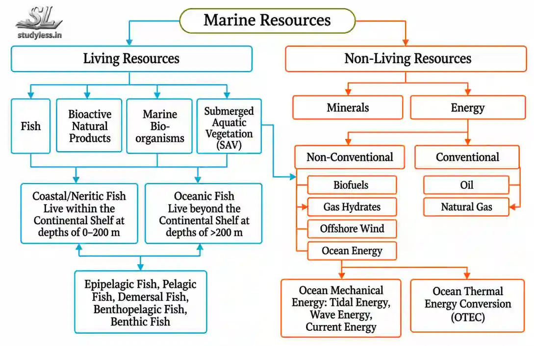
Marine Resources
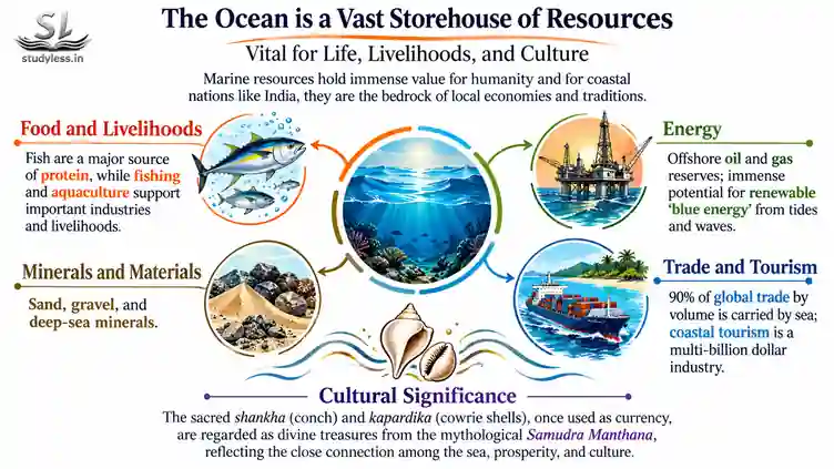
● Oceans = vast storehouses of resources
● Marine resources = materials and features in oceans
●●●⁍ Have intrinsic or economic value
● Classification:
●●●⁍ Marine Living Resources
●●●⁍ Marine Non-living Resources
●●●●●▸Examples:
●●●●●●●●1. Sand and gravel 2. Fish and seafood
●●●●●●●●3. Biodiversity 4. Oil and natural gas
●●●●●●●● 5. Minerals 6. Sand and gravel
●●●●●●●●●●●●●7. Renewable blue energy:
●●●●●●●●●●●●●●●●●●●●▸Tidal energy
●●●●●●●●●●●●●●●●●●●●▸Wave energy
●●●●●●●●●●●●●8. Tourism potential 9. Unique ecosystems {Coral reefs}
Significance of Marine Resources
● Vital for
●●●●⁍ Food security
●●●●⁍ Economic activities
●●●●⁍ Healthy environment
● Oceans support biodiversity
●●●●⁍ Sustain plant and animal species
For India:
Long coastline ➜ fishing, trade, tourism ➜ livelihoods for millions
Therefore:
● Use marine resources responsibly
● Do not disturb marine ecosystems
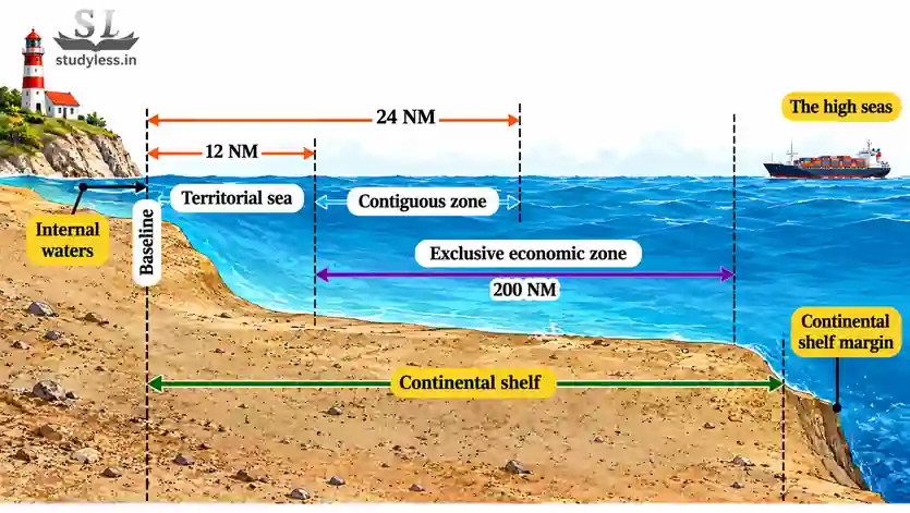
Maritime Zones
❖ Maritime zones = different areas of ocean
●●⁍ Defined by international law
●●●▸Territorial waters ➜ Contiguous zone ➜ EEZ ➜ High seas
❖ Territorial waters
●●● Sea area closest to a country
●●●⁍Feature
●●●●▸Near-complete control of the country
●●●●▸Foreign ships may pass peacefully if they obey the rules
●●● Government can make laws on:
●●●●⁍ Customs
●●●●⁍ Immigration
●●●●⁍ Pollution control
❖ Contiguous Zone
●●● Beyond territorial waters
●●● From baseline up to 24 nautical miles
●●● Limited control over:
●●●●⁍ Customs
●●●●⁍ Fiscal matters
●●●●⁍ Illegal immigration
❖ Exclusive Economic Zone (EEZ)
●●● Beyond contiguous zone
●●● Up to 200 nautical miles from coast
●●● Defined under UNCLOS by global agreement
●●●●⁍ UNCLOS= United Nations Convention on the Law of the Sea
●●● Special rights to use ocean resources:
●●●●⁍ Fish
●●●●⁍ Oil
●●●●⁍ Gas
●●● Other countries' ships pass peacefully
●●● Country does not fully own or control EEZ waters
❖ High Seas
●●● Beyond the EEZ
●●● Also called international waters
●●● 64 per cent of world's oceans
●●●●⁍ Feature
●●●●●●▸Belong to no single country
●●●●●●▸Part of the global commons
●●●●●●▸Equal rights for all countries:
●●●●●●●●●⁃ Navigation
●●●●●●●●●⁃ Fishing
●●●●●●●●●⁃ Flying over
●●●●●●●●●⁃ Laying underwater cables
●●●●●●●●●⁃ Building floating structures
●●●●●●●●●⁃ Exploring for minerals
Challenges of EZZ:
●●⁍ Overfishing ⁍ Illegal fishing ⁍ Conflicts over resources
●●⁍ Navigation and safety harder to ensure
●●⁍ No clear enforcement mechanisms
●●●●▸Law that applies: flag state
●●●●●●●●⁃ Country in which a ship is registered
International Maritime Rules and Regulations
Maritime Law/Maritime regulations
International rules and agreements for keeping Keep activities at sea safe, fair, and peaceful
Maritime Law regulates:
●Piracy ●Terrorism ●Natural disasters ●Accidents ●Trade route safety
●Disputes between countries
Important Maritime Rules and Regulations
COLREGs| Avoids accidents at sea
= Convention on the International Regulations for Preventing Collisions at Sea
●●● Sets rules of the road at sea
●●●⁍ Feature
●●●●▸lookout
●●●●▸Deciding which ship to pass on
●●●●▸Give-way and stand-on vessels
●●●●▸Safe speed
●●●●▸Lights, sound signals, shapes
●●●●●●⁃ Shapes mark vessel types (e.g. fishing boats)
●●●●●●●▸Prevent collisions
●●●●●●●▸International signals and radio communication
MARPOL | Reduce ship pollution
= International Convention for the Prevention of Pollution from Ships
●●⁍ Feature:
●●●●▸Ships meet safety standards
●●●●▸Ships prohibited from polluting seas
COLREGs ➜ proper lookout, signals, safe speed ➜ collisions prevented
MARPOL ➜ no polluting by ships ➜ cleaner seas
Why are Maritime Rules Important?
● Safe oceans ●fair + sustainable use of resources
● Use marine resources without conflict
◈Protects:
●●⁍ Marine life
●●⁍ ● Ships
●●⁍ ● Sailors
●●⁍ ● Coastal communities
●●⁍●●⁍● Common standards for all ships
please give me very shorts notes to learn easily.
Hi Bhavika, We create notes for general user. We make a balance between learning and revising in our notes. Please specify if you want to notes for fast revision and retention of important points. We will come up with a design and format for that also.
Pls create notes for ch 3 resistance and resilience as it is coming in my ut2 soon
Tommorrow ch 3 resistance and resilience will be published
ch 3 resistance and resilience notes published