
“Ch 2 Shaping Of The Earth’s Surface Notes Class 9“ is created after multiple readings and consultations with our students.
We have created the short notes from Chapter 2 Shaping of the Earth’s Surface NCERT Class 9 Understanding Society: India and Beyond.
We have included in the notes:
- Comparision tables
- HD Images
- Headings and subheadings for long complex topics
- And some other novel things
- Images with proper detailing are provided before the topic starts. This will help you to master the topic easily
These will help you to master the chapter Chapter 2 Shaping of the Earth’s Surface in less time with proper retention.
Also Read| Ch 1 Understanding Social Science Notes Class 9 Social Science
Ch 2 Shaping Of The Earth’s Surface Notes Class 9
Why Should We Study the Earth’s Surface?
Forces of Change
- The Earth’s surface is constantly changing.
- These changes are caused by internal and external forces.
Plate Tectonics
- Plate tectonics explains how large crustal plates move over the molten mantle.
- Their movement creates different landforms.
Major Landforms
- Mountains
- Volcanoes
- Plains
- Valleys
Importance
- Explains earthquakes, volcanic eruptions, and the formation of continents and oceans.
- Helps us understand the dynamic nature of the Earth.
What Is Plate Tectonics?
Plate tectonics is when giant pieces of Earth’s crust move and collide.
- W. J. Morgan proposed the Plate Tectonics Theory.
- It explains the movement of the Earth’s crust.
How It Works
- The Earth’s outer layer is divided into tectonic plates.
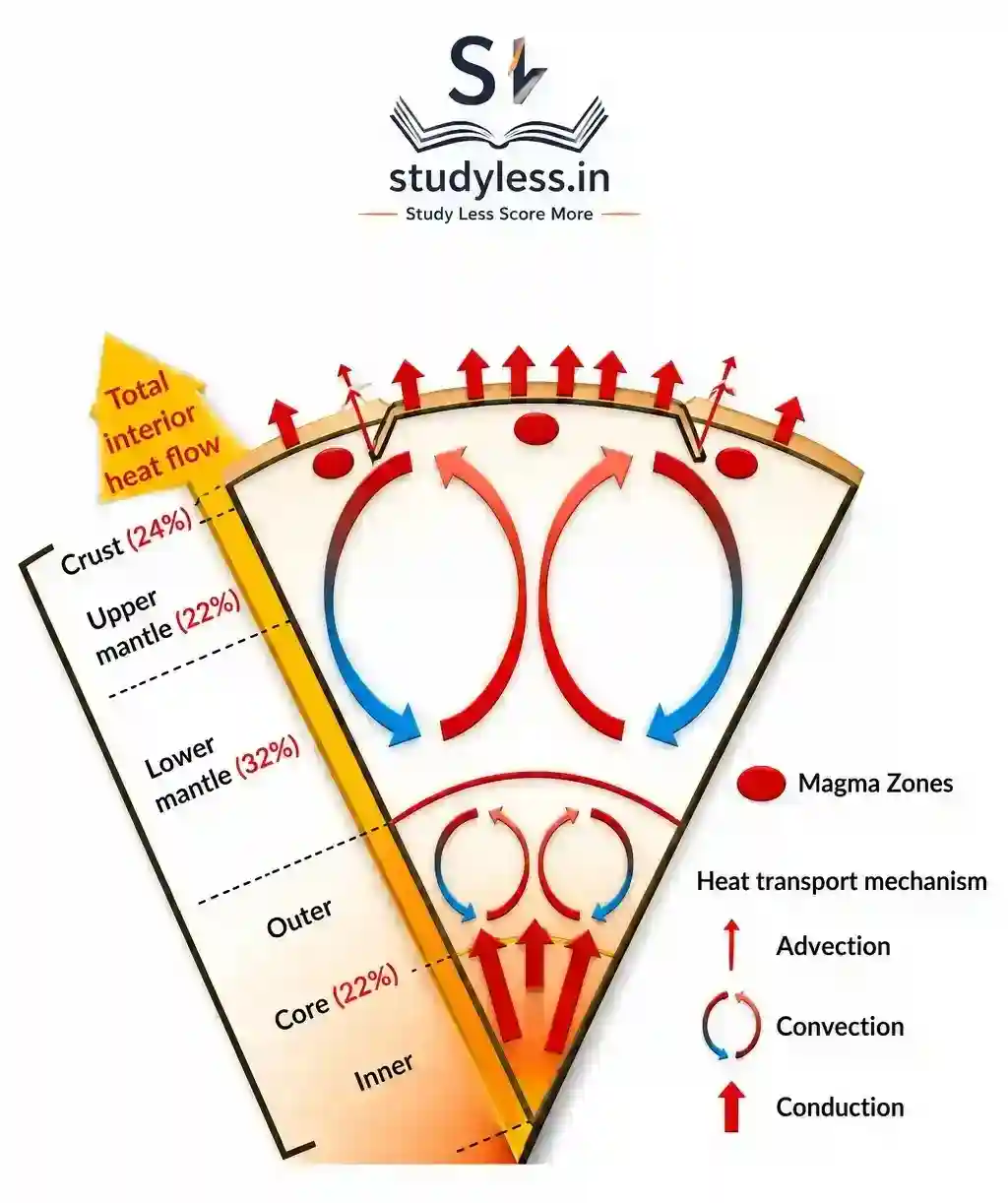
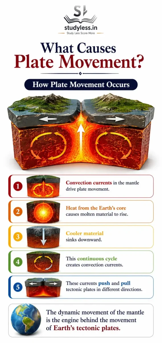
- These plates move slowly over the semi-molten mantle.
What It Creates
- Mountains
- Earthquakes
- Volcanoes
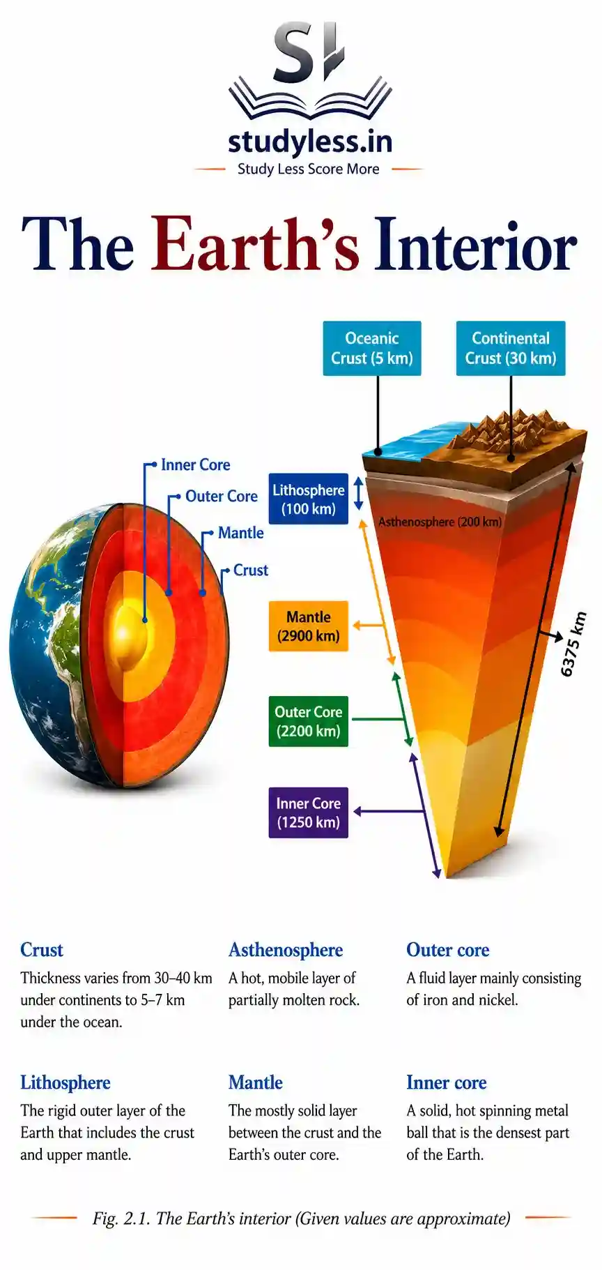
What are the Layers of the Earth?
| Layer | Feature |
|---|---|
| Crust | Outermost layer. We live on it. |
| Mantle | Below the crust. Very thick and hot. |
| Core | Innermost layer. Extremely hot and heavy. |
- Lithosphere = Crust + upper part of mantle.
- The lithosphere is broken into tectonic plates.
- The asthenosphere lies below the lithosphere. It is semi-molten. It lets plates move.
What are Tectonic Plates?
- Tectonic plates are massive slabs of solid rock.
- They move very slowly. Usually a few centimetres per year.
Types of Tectonic Plates
- Continental plates: carry continents.
- Oceanic plates: carry ocean floors.
- Mixed plates: carry both continents and oceans.
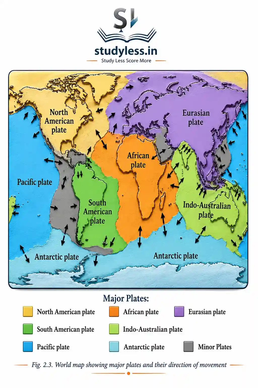
Major Tectonic Plates of the World
- Pacific Plate
- Eurasian Plate
- African Plate
- North American Plate
- South American Plate
- Indo-Australian Plate
- Antarctic Plate
What Causes Plate Movement?
What are Plate Boundaries?
- Plate boundary = edge where tectonic plates meet.
- There are three main types.
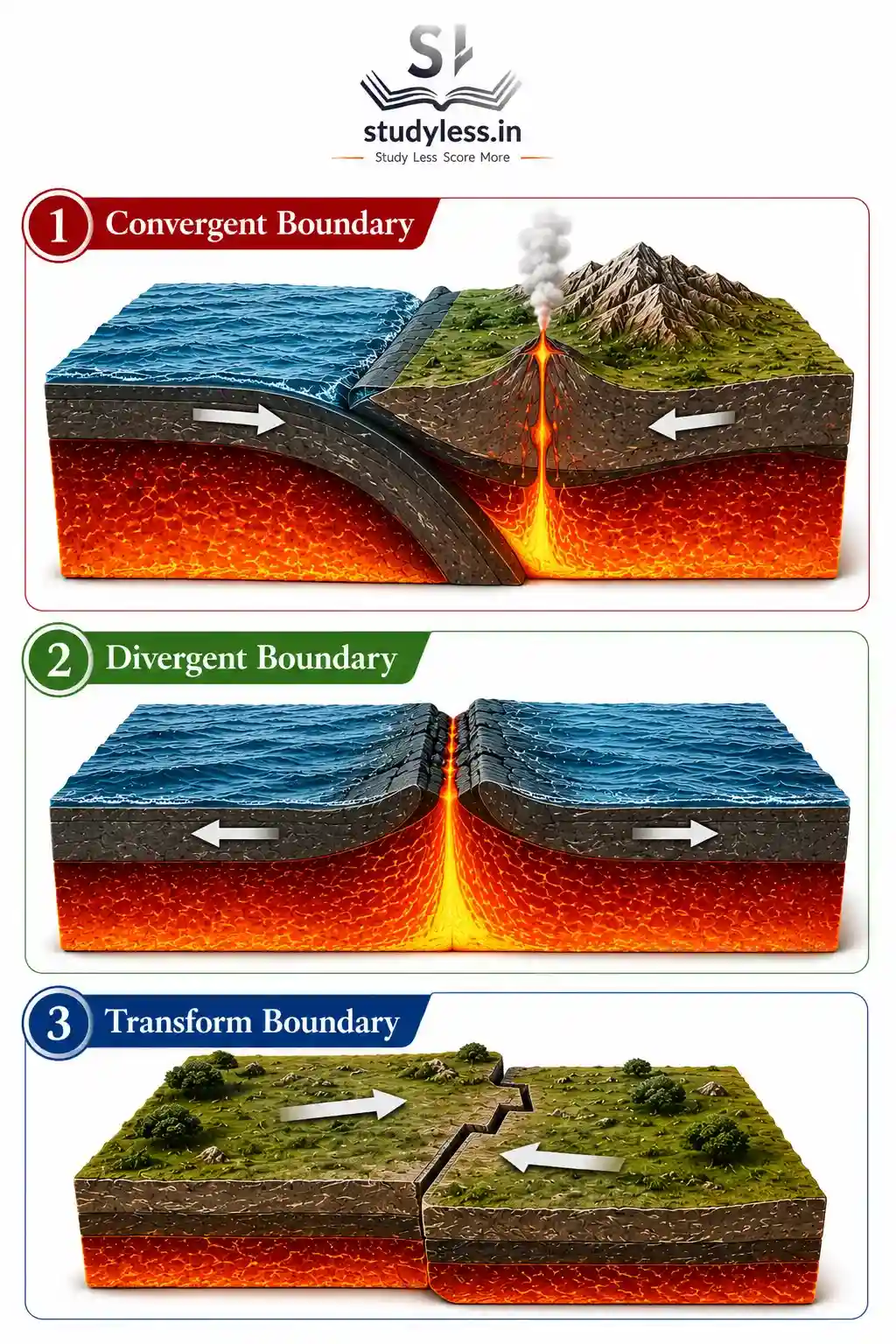
1. Convergent Boundary
- Two plates move towards each other.
- Continental + Continental collision → forms fold mountains (e.g., Himalaya).
- Oceanic + Continental collision → oceanic plate sinks beneath continental plate → causes volcanic activity and earthquakes.
2. Divergent Boundary
- Plates move away from each other.
- Magma rises from below. Forms new crust.
- Creates features like mid-ocean ridges.
- Example: Mid-Atlantic Ridge.
3. Transform Boundary
- Plates slide past each other.
- No crust is created or destroyed.
- Mainly causes earthquakes.
- Example: San Andreas Fault, United States.
| Boundary Type | Plate Movement | Result |
|---|---|---|
| Convergent | Towards each other | Mountains, volcanoes, earthquakes |
| Divergent | Away from each other | New crust, mid-ocean ridges |
| Transform | Slide past each other | Earthquakes |
Why is Plate Tectonics Important?
1. Impact on the Earth’s Surface
- Plate movement shapes the Earth’s surface.
- It forms:
- Mountains
- Valleys
- Ocean basins
- Volcanoes
- Earthquakes
2. Explaining Earth’s Features
- Explains the distribution of continents and oceans.
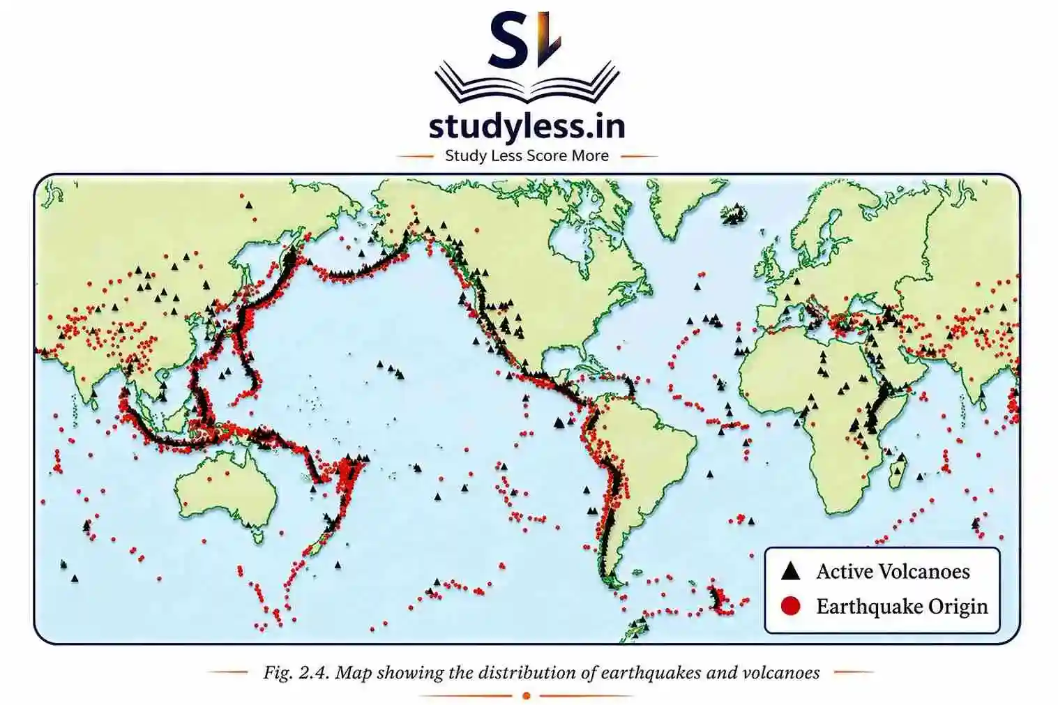
- Most earthquakes and volcanoes occur along plate boundaries.
3. Ring of Fire
- The Ring of Fire surrounds the Pacific Ocean.
- It has the highest concentration of earthquakes and volcanoes.
Conclusion
Plate tectonics:
Explains constant change in Earth’s surface.
Explains the origin of landforms and natural disasters
Identifying earthquake and volcano-prone regions.
Helps in disaster management.
Process of Weathering and Erosion
Weathering breaks down rocks. Erosion moves the broken material. Together they shape mountains, valleys, plains, caves, cliffs, and river deltas.
What Is Weathering?
Definition
- Weathering is the process by which rocks break down into smaller pieces on the Earth’s surface.
How It Happens
- It breaks rocks into smaller fragments.
- The broken material does not move.
- Only breaking down occurs, not transportation.
Importance
- Helps shape the Earth’s surface.
- Plays a key role in soil formation.
Common Confusion:
Weathering breaks rocks in place.
Erosion moves the broken pieces away. Don’t mix the two
What are the Types of Weathering?
1. Physical Weathering
- Rocks break into smaller pieces.
- Caused by temperature changes, frost, or wind.
2. Chemical Weathering
- Minerals in rocks change.
- Caused by reactions with water, air, or acids.
- Leads to the formation of new substances.
3. Biological Weathering
- Caused by plants, animals, or micro-organisms.
- Example: plant roots grow into cracks in rocks and split them apart.
| Type | Cause |
|---|---|
| Physical | Temperature, frost, wind |
| Chemical | Water, air, acids |
| Biological | Plants, animals, micro-organisms |
What Is Erosion?
Definition
- Erosion is the process by which soil, rocks, and other surface materials are worn away and transported from one place to another.
Agents of Erosion
Erosion is caused by:
- Water
- Wind
- Ice
- Waves
How It Differs from Weathering
- Weathering only breaks down rocks.
- Erosion breaks down and transports the material.
Importance
- Shapes landforms.
- Can both create and destroy features on the Earth’s surface.
What are the Types of Erosion?
- Water erosion: caused by rivers, rain, or ocean waves.
- Wind erosion: common in dry and sandy areas.
- Glacial erosion: moving ice scrapes and carries rocks.
- Coastal erosion: sea waves wear away land along the shore.
How Does Erosion Affect Human Occupations?
Impact on Farming
- Removes fertile topsoil.
- Reduces crop yields.
Impact on Settlements
- Washes away land, houses, and roads.
- Causes property damage.
Impact on Construction and Mining
- Makes the land unstable.
- Increases safety risks.
Impact on Tourism and Fishing
- Damages beaches, rivers, and fertile land.
- Affects tourism and fishing livelihoods.
Conclusion
- Weathering = breaking down rocks (no movement).
- Erosion = wearing away + carrying material (movement).
- Both work together over long periods of time.
- They form mountains, valleys, plains, caves, cliffs, river deltas.
- Erosion has direct impact on human life and work.
Agents of Gradation
Agents of gradation are natural forces that wear down, carry, and deposit material on Earth’s surface. They level the surface over time.
What are Agents of Gradation?
- Agents of gradation are natural forces that wear down, transport, and deposit materials on Earth’s surface.
- They help to level or smooth the surface over time.
Main Agents of Gradation
| Agent | Work Done |
|---|---|
| Running water | Erodes rocks and soils. Forms valleys and plains. |
| Glaciers | Scrape and carry material. Carve U-shaped valleys. |
| Wind | Shapes deserts by eroding and depositing sand. |
| Sea waves | Erode coastlines. Form cliffs, beaches, bays. |
| Groundwater | Dissolves rocks like limestone. Creates caves and sinkholes. |
How Does Running Water Shape Land?
- Rivers shape land through erosion, transportation, and deposition.
- Creates different landforms along its course.
River Course Stages
| Course | Features Formed | Reason |
|---|---|---|
| Upper course | V-shaped valleys, waterfalls, rapids | Steep gradient, strong erosion |
| Middle course | Meanders, oxbow lakes, floodplains | River loses energy, deposits sediments |
| Lower course | Deltas, levees, alluvial fans | The river slows, deposits large sediment |
These landforms are important for agriculture, settlement, and ecosystems.
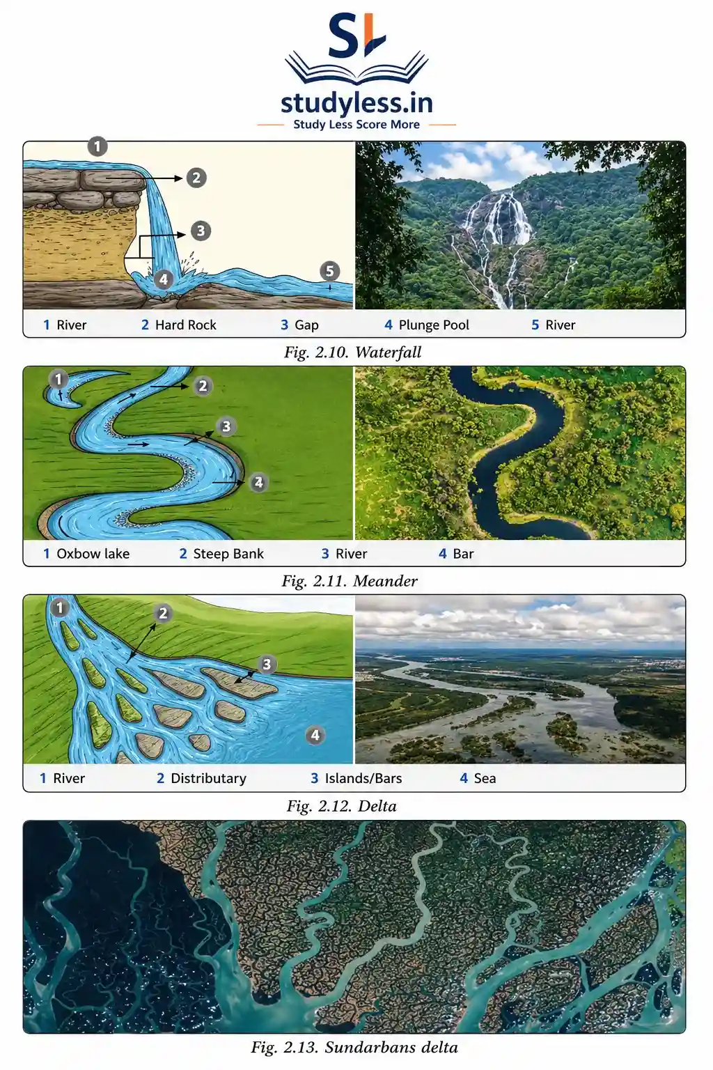
What is a Waterfall?
- A waterfall is a landform where a river flows over a steep cliff or vertical drop, creating a dramatic fall.
- Forms in the upper course of rivers.
- Hard rocks resist erosion. Softer rocks below get worn away. This creates a sudden drop.
Importance of Waterfalls
- Attract tourists. Important for local tourism and economy.
- Used for hydroelectric power generation.
- Provide recreation — trekking, photography.
- Hold cultural or religious significance in certain regions.
What is a Meander?
- A meander is a winding curve or bend in the middle or lower course of a river.
- The river erodes the outer banks of bends.
- The river deposits sediment on the inner banks.
- This gradually creates large loops.
Importance of Meanders
- Fertile soil deposited along banks supports agriculture.
- Influence settlement patterns — villages/towns develop on gentle slopes near meanders.
- Used for navigation, irrigation, and sometimes tourism.
Example: Grand Anicut (also called Kallanai), Tamil Nadu — example of rivers used for irrigation.
What is a Delta?
- A delta is a landform formed at the mouth of a river, where it flows into a sea, ocean, or lake.
- Rivers deposit sediments carried from upstream.
- Over time, deposits form a fan-shaped or triangular area of land.
Importance of Deltas
- Highly fertile due to rich alluvial soil. Good for agriculture (rice, jute).
- Important for fishing — mix of fresh and saltwater creates diverse aquatic life.
- Support dense human settlements.
- Centres of trade and transportation — rivers give navigable routes.
- Risk: prone to flooding, affecting human life and activities.
Conclusion
- River course = Upper (erosion) → Middle (meanders) → Lower (deposition/delta).
- Waterfalls form due to hard rock over soft rock.
- Meanders and deltas both support agriculture and settlement.
- Deltas = fertile but flood-prone.
Waves and Currents
Waves and currents reshape coastal land. They create beaches, sand bars, sea cliffs, caves, arches, and stacks.
What is a Beach?
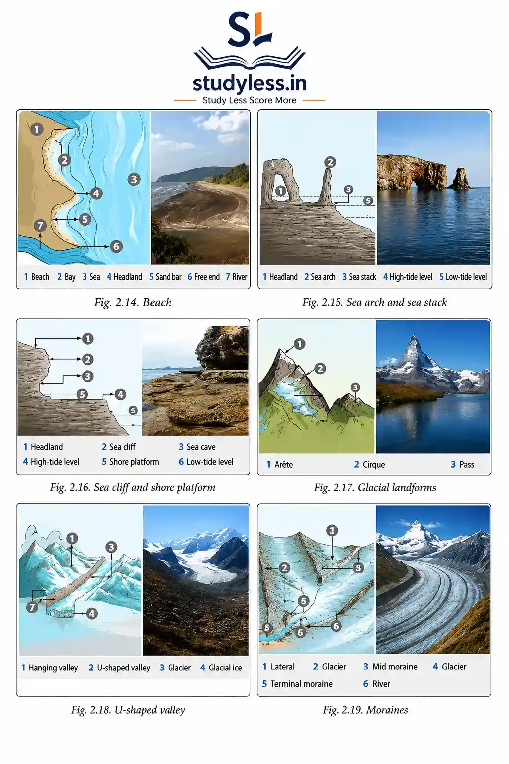
- A beach is a landform made up of sand, pebbles, or rocks along the shoreline.
- Created by deposition of sediments by waves.
- Shaped continuously by wave action, tides, and currents.
Importance of Beaches
- Popular tourist destinations — relaxation, swimming, recreation.
- Boosts local economy.
- Provide fishing areas.
- Some communities collect sand and shells here.
- Act as natural barriers against strong waves and coastal erosion.
What is Coastal Erosion?
- Occurs when waves, tides, and currents wear away land along the coast.
- Creates unique landforms.
Landforms of Coastal Erosion
| Landform | How it Forms |
|---|---|
| Cliffs | Steep rock faces. Waves undercut the base of the coast. |
| Wave-cut platforms | Flat areas left behind as cliffs retreat. |
| Caves | Waves erode weak parts of rock. |
| Arches | Caves on opposite sides of headland meet. |
| Stacks | Isolated rock pillars after arches collapse. |
“Cliff → Platform → Cave → Arch → Stack”
This is the order of formation; one leads to the next.
Glaciers
Moving ice is called a glacier
What is Glacial Erosion?
- Occurs when glaciers slowly move over land.
- Carves and shapes the landscape.
Landforms of Glacial Erosion
| Landform | Feature |
|---|---|
| U-shaped valleys | Glaciers widen and deepen river valleys. |
| Cirques | Bowl-shaped depressions at head of glacier. |
| Aretes | Sharp ridges between valleys. |
| Hanging valleys | Where smaller glaciers meet larger ones. |
| Fjords | Deep, narrow inlets when sea floods glacial valleys. |
Importance to Humans
- U-shaped valleys & cirques:
Tourist attractions — trekking, skiing, mountaineering. - Fjords:
Used for harbours and fishing. - Glacial soil:
Supports agriculture in some valleys. - Glaciers:
Crucial source of fresh water, feed rivers.
What are Moraines?
- Moraines are landforms created by deposition of rocks, soil, and debris (called till).
- Formed when a glacier melts and deposits eroded material.
Types of Moraines
- Lateral moraines: form along the sides of glaciers.
- Terminal moraines: found at the end of glaciers. Mark the furthest advance.
- Medial moraines: formed when two glaciers meet. Their lateral moraines join in the middle.
Common Confusion:
- Lateral = sides.
- Terminal = end point.
- Medial = middle (where two glaciers join).
Importance of Moraines
- Create fertile soil for agriculture.
- Form natural dams and lakes.
- Used for water supply, irrigation, sometimes hydroelectric power.
Wind
What is Wind Erosion?
- Occurs when strong winds pick up and carry away loose sand and soil particles.
- Gradually shapes the landscape.
Landforms of Wind Erosion
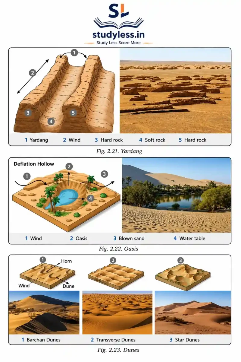
| Landform | Feature |
|---|---|
| Yardangs | Streamlined rock ridges carved by wind. |
| Ventifacts | Rocks polished and shaped by sandblasting. |
| Deflation hollows / blowouts | Shallow depressions where loose material is removed. |
| Desert pavements | Flat surfaces left after finer particles are blown away. |
Importance to Humans
- Influence settlement patterns and agriculture in arid regions.
- Ventifacts and yardangs attract tourists and geologists.
What are Dunes?
- Dunes are hills or ridges of sand formed by wind.
- Found in desert areas or along sandy coasts.
Types of Dunes
- Barchan dunes: crescent-shaped. Form with limited sand, a single wind direction.
- Longitudinal dunes: long ridges. Parallel to the prevailing wind.
- Star dunes: multiple arms. Form where winds come from different directions.
- Parabolic dunes: U-shaped. Often stabilised by vegetation.
Importance of Dunes
- Act as natural barriers against desertification and wind erosion.
- Provide areas for tourism and adventure sports.
- Protect coastal settlements from strong sea winds and waves.
- Sand used for construction purposes.
Underground Water
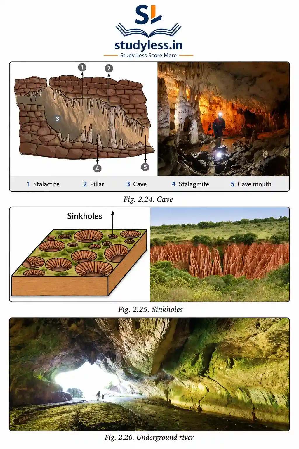
What is Karst Topography?
- Underground water, especially in limestone or soluble rocks, creates Karst topography.
- Formed through chemical weathering and erosion.
Landforms of Underground Water
| Landform | Feature |
|---|---|
| Caves | Hollow spaces. Acidic water dissolves rock. |
| Stalactites | Icicle-shaped formations hanging from the cave ceiling. |
| Stalagmites | Formations rising from the cave floor. |
| Sinkholes / dolines | Depressions when ground collapses into underground cavity. |
| Underground rivers | Flow-through cave systems. |
Common Confusion:
- Stalactite = hangs from ceiling (think “tite” = tight grip from top).
- Stalagmite = rises from ground (think “mite” = might grow up).
Importance to Humans
- Source of fresh water.
- Tourism opportunities.
- Cultural or religious significance in some cases.
- Stalagmites/stalactites attract geologists and adventurers.
Conclusion
| Agent | Key Landforms |
|---|---|
| Waves/Currents | Beach, cliff, cave, arch, stack |
| Glaciers | U-shaped valley, cirque, fjord, moraine |
| Wind | Yardang, ventifact, dune |
| Underground water | Cave, stalactite, stalagmite, sinkhole |
Landforms and Disasters
Different landforms can cause disasters. Four common ones are landslides, avalanches, GLOFs, and dust storms.
What Causes Landslides?
Natural Causes
- Heavy and continuous rainfall — water seeps into soil/rocks. Increases weight. Reduces friction.
- Earthquakes and volcanic eruptions — shake ground. Weaken slopes.
- Steep slopes with loose or weathered rocks — increase risk.
Human Causes
- Deforestation, mining, road construction — disturb slope balance.
- Unplanned construction on hillsides.
- Poor drainage systems and improper land use — water accumulates. Leads to slope failure.
What Causes Avalanches?
- Sudden instability of snow on steep slopes.
- Weak or loosely bonded layers of snow make snowpack unstable.
- Sudden temperature rise — causes partial melting. Reduces friction holding snow together.
- Strong winds — pile up snow unevenly. Creates fragile layers.
Triggers
- Natural: earthquakes and vibrations.
- Human: skiing, trekking, construction in mountainous areas.
Common Confusion:
- Landslide = rocks/soil moving down slope.
- Avalanche = snow moving down slope.
What are GLOFs?
- GLOFs = Glacial Lake Outburst Floods.
- Caused by sudden release of large volumes of water from glacial lakes.
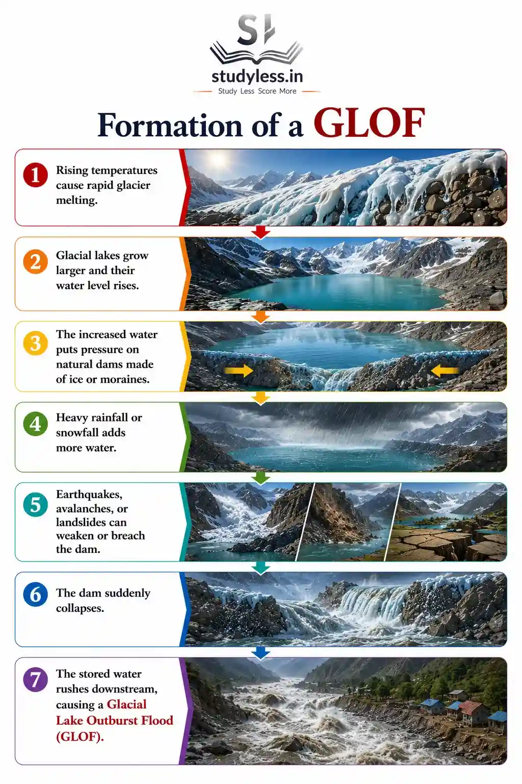
How GLOFs Happen
Formation of a GLOF
- Rising temperatures cause rapid glacier melting.
- Glacial lakes grow larger and their water level rises.
- The increased water puts pressure on natural dams made of ice or moraines.
- Heavy rainfall or snowfall adds more water.
- Earthquakes, avalanches, or landslides can weaken or breach the dam.
- The dam suddenly collapses.
- The stored water rushes downstream, causing a Glacial Lake Outburst Flood (GLOF).
What Causes Dust Storms?
- Caused by strong winds lifting large amounts of loose, dry soil and sand into the air.
Contributing Factors
- Prolonged drought and low rainfall
Dries out soil. Makes it easy for wind to lift particles. - Desert and semi-arid regions
Soil is loose and dry. - Sparse vegetation cover
Due to deforestation, overgrazing, poor farming practices. Leaves land exposed. - Climate change and extreme weather
Increases frequency and intensity.
Disaster Comparison Table
| Disaster | Main Trigger | Region |
|---|---|---|
| Landslide | Rainfall, earthquakes, deforestation | Slopes, hills |
| Avalanche | Temperature rise, wind, vibrations | Snow-covered mountains |
| GLOF | Glacier melting, dam collapse | Glacial lake areas |
| Dust Storm | Strong winds, drought | Desert, semi-arid regions |
Conclusion
The Dynamic Earth
- Internal forces (earthquakes, volcanic eruptions, folding, and faulting) create mountains, valleys, and ocean basins.
- External forces (weathering, erosion, and deposition) continuously wear down and reshape these landforms.
- Together, these forces create the Earth’s diverse landscapes, from the highest mountains to the deepest ocean floors.
Why It Matters
- Landforms influence climate, natural resources, human settlements, and culture.
- Understanding the Earth’s surface helps us prepare for natural disasters and use natural resources more wisely.



Very good notes i love very much these are notes that provide less study and score more
Thnaks!