
Tired of long paragraphs and confusing geography notes?
You’re not alone. Most students read the same page over and over — but nothing sticks. And “Physical Features of India Class 9 Short Notes” is the solution to the problem.
This summary cuts the clutter.
No fluff. No jargon. Just short, clear, exam-focused points — organized for quick learning and fast revision.
Every keyword, map point, and question from your chapter is covered — in the simplest way possible.
Study smart. Remember more. Stress less.
You can click on the burger button in the table of contents below to collapse the table of contents. The button is on the top right of the table of contents.
The Himalayan Mountains
- Location: North of India, arc-shaped, 2,400 km long (Indus to Brahmaputra).
- Width: 400 km (Kashmir) to 150 km (Arunachal).
- Young fold mountains, geologically unstable.
Three Parallel Ranges (North to South)
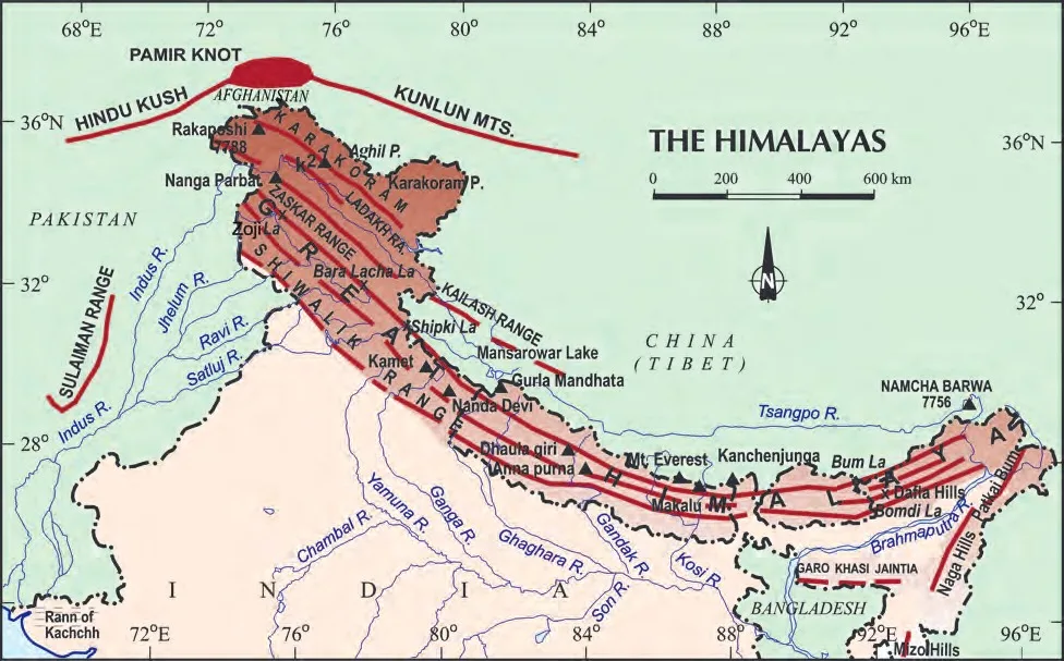
Image source: NCERT
1. Himadri (Great Himalayas)
- Highest, continuous range.
- Avg. height: 6,000 m.
- Contains Mt. Everest (8,848 m), Kanchenjunga (8,598 m), Nanga Parbat, Nanda Devi.
- Core: granite; perennial snow & glaciers.
2. Himachal (Lesser Himalayas)
- Altitude: 3,700–4,500 m.
- Rugged, compressed rocks.
- Valleys: Kashmir, Kangra, Kullu.
- Hill stations: Shimla, Mussoorie, Nainital, Ranikhet.
3. Shiwaliks (Outer Himalayas)
- Lowest range: 900–1,100 m.
- Made of unconsolidated sediments from rivers.
- Duns (valleys): Dehra Dun, Patli Dun, Kotli Dun.
Regional Divisions (West to East)
- Punjab Himalayas: Indus to Satluj (J&K, Himachal).
- Kumaon Himalayas: Satluj to Kali.
- Nepal Himalayas: Kali to Teesta.
- Assam Himalayas: Teesta to Dihang.
Purvachal (Eastern Hills)
- Beyond Dihang Gorge → bend south → form Purvachal.
- Includes: Patkai, Naga, Manipur, Mizo Hills.
- Made of sandstone, dense forests, parallel ranges.
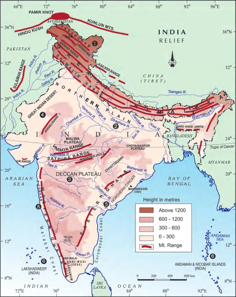
Image source: NCERT
The Northern Plains
- Formed by Indus, Ganga, Brahmaputra and tributaries.
- Alluvial soil, fertile, flat.
- 7 lakh sq km, 2,400 km long → most densely populated & agriculturally rich.
River Terms
- Doab: Land between two rivers (e.g., Punjab has five rivers → five doabs).
- Distributaries: Rivers split in lower course (e.g., Sunderbans).
- Majuli: World’s largest inhabited river island (Brahmaputra, Assam).
Three Sections Of The Northern Plains
- Punjab Plains: Indus & tributaries (Jhelum, Chenab, Ravi, Beas, Satluj) → mostly in Pakistan.
- Ganga Plain: Ghaggar to Teesta → covers Haryana, UP, Bihar, Bengal.
- Brahmaputra Plain: In Assam.
Relief Features (North to South)
- Bhabar: Narrow (8–16 km), pebbles deposited, rivers disappear.
- Terai: South of Bhabar, rivers reappear, marshy, thick forests (e.g., Dudhwa National Park).
- Bhangar: Older alluvium, above floodplains, contains kankar (calcium deposits).
- Khadar: Newer alluvium, fertile, renewed yearly → ideal for farming.
The Peninsular Plateau
- Oldest landmass (from Gondwana breakup).
- Made of igneous & metamorphic rocks.
- Tableland with rounded hills, shallow valleys.
Two Main Parts Of Peninsular India
Central Highlands
- North of Narmada River.
- Includes Malwa Plateau.
- Bounded by the Vindhyas (south) and Aravalis (northwest).
- Rivers: Chambal, Betwa, Ken → flow southwest to northeast.
- Eastward extensions: Bundelkhand, Baghelkhand, Chotanagpur Plateau (Damodar River).
Deccan Plateau
- South of Narmada. Triangular, slopes eastwards.
- Higher in west, lower in east.
- Flanked by Satpura (north), Mahadev, Maikal (east).
Northeast Extension Of Peninsular Plateau
- Meghalaya, Karbi-Anglong, North Cachar Hills.
- Separated from Chotanagpur by fault.
- Hills: Garo, Khasi, Jaintia.
Western and Eastern Ghats
| Feature | Western Ghats | Eastern Ghats |
|---|---|---|
| Location | Along Arabian Sea | Along Bay of Bengal |
| Continuity | Continuous, crossed only via passes | Discontinuous, cut by rivers |
| Height | 900–1600 m (higher) | ~600 m (lower) |
| Rainfall | Causes orographic rain | Less rainfall |
| Highest Peak | Anai Mudi (2,695 m) | Mahendragiri (1,501 m) |
| Local Names | Sahyadri | Nilgiris, Javadi, Shevroy Hills |
- Western Ghats: Higher, block rain, cause heavy rainfall on west coast.
- Eastern Ghats: Broken, rivers like Godavari, Krishna cut through.
Special Features Of Peninsular India
- Deccan Trap: Volcanic black soil region → ideal for cotton.
- Aravali Hills: Oldest fold mountains in India → from Gujarat to Delhi → highly eroded.
The Indian Desert (Thar Desert)
- Lies west of the Aravali Hills.
- Arid: <150 mm rainfall/year.
- Sandy plain with dunes (e.g., barchans near Jaisalmer).
- Luni River: only large river → disappears in sand.
- Streams appear in the monsoon, vanish quickly.
The Coastal Plains
Western Coastal Plains (Narrow)
- Between Western Ghats and Arabian Sea.
- Konkan (Mumbai–Goa), Kannad Plain, Malabar Coast (Kerala).
Eastern Coastal Plains (Wide)
- Between the Eastern Ghats and Bay of Bengal.
- Northern Circar (Odisha, Andhra), Coromandel Coast (Tamil Nadu).
- Rivers form deltas: Mahanadi, Godavari, Krishna, Kaveri.
- Chilika Lake: Largest saltwater lake in India (Odisha).
The Islands
Lakshadweep Islands
- In the Arabian Sea, near Kerala coast.
- Coral origin (from coral polyps).
- Area: 32 sq km. Capital: Kavaratti.
- Pitti Island: bird sanctuary.
- Formerly: Laccadive, Minicoy, Amindive → renamed in 1973.
Andaman and Nicobar Islands
- In Bay of Bengal, north-south chain.
- Volcanic origin (submarine mountains).
- Andaman (north), Nicobar (south).
- Equatorial climate, thick forests, rich biodiversity.
- Barren Island: India’s only active volcano.
- High strategic importance.
FAQs Physical Features of India Class 9 Short Notes
What are the six major physiographic divisions of India?
✅ Answer:
The six major divisions are:
- The Himalayan Mountains
- The Northern Plains
- The Peninsular Plateau
- The Indian Desert
- The Coastal Plains
- The Islands
Why are the Himalayas called young fold mountains?
✅ Answer:
The Himalayas are called young fold mountains because:
- They were formed relatively recently in Earth’s history (about 50 million years ago).
- Formed by the folding of the Earth’s crust due to the collision of the Indo-Australian and Eurasian plates.
- Still geologically active (unstable), with ongoing uplift, earthquakes, and high peaks.
What is the difference between Bhangar and Khadar?
✅ Answer:
| Bhangar | Khadar |
|---|---|
| Older alluvium | Newer alluvium |
| Lies above floodplains | Lies below, near riverbeds |
| Contains kankar (calcium deposits) | Fertile, renewed every year |
| Less suitable for farming | Ideal for intensive agriculture |
Which is the highest peak in India?
✅ Answer:
Kanchenjunga (8,598 m) is the highest peak in India and the 3rd highest in the world.
It is located in Sikkim in the Himalayas.
⚠️ Note: Mt. Everest is the highest in the world but lies in Nepal, not India.
What are Duns? Name some examples.
✅ Answer:
Duns are longitudinal valleys between the Lesser Himalayas (Himachal) and the Shiwaliks.
They are filled with alluvium and gravel.
Examples: Dehra Dun, Kotli Dun, Patli Dun.
Why is the Northern Plain so important for India?
✅ Answer:
The Northern Plain is important because:
- Made of fertile alluvial soil → ideal for agriculture.
- Supports major crops like wheat, rice, sugarcane → called “Granaries of India”.
- Has dense population due to flat land, good climate, and water supply.
- Home to early civilizations (Indus Valley, Ganga Valley).
What is a Doab? Where is it found?
✅ Answer:
- Doab = “Do” (two) + “Ab” (water) → land between two rivers.
- Found in the Punjab Plains (e.g., between Beas and Sutlej → Bari Doab).
- The term is also used in the Ganga Plain.
What is the Deccan Trap? Why is it important?
✅ Answer:
- The Deccan Trap is a region of black soil in the Peninsular Plateau.
- Formed by volcanic lava flows millions of years ago.
- Soil is fertile, ideal for growing cotton → also called black cotton soil.
How are the Western Ghats different from the Eastern Ghats?
✅ Answer:
| Feature | Western Ghats | Eastern Ghats |
|---|---|---|
| Location | Along Arabian Sea | Along Bay of Bengal |
| Continuity | Continuous | Discontinuous |
| Height | Higher (900–1600 m) | Lower (~600 m) |
| Rainfall | Causes heavy orographic rain | Less rainfall |
| Highest Peak | Anai Mudi (2,695 m) | Mahendragiri (1,501 m) |
What are coral islands? Give an example.
✅ Answer:
- Coral islands are formed from the skeletons of tiny marine organisms called coral polyps.
- They live in warm, shallow, clear water and secrete calcium carbonate, forming reefs.
- Lakshadweep Islands are coral islands in the Arabian Sea.
Where is India’s only active volcano located?
✅ Answer:
India’s only active volcano is on Barren Island, which is part of the Andaman and Nicobar Islands in the Bay of Bengal.
What is the significance of the Peninsular Plateau?
✅ Answer:
The Peninsular Plateau is significant because:
- Oldest landmass in India → stable.
- Rich in minerals (iron, coal, manganese) → supports industries.
- Source of many rivers (Godavari, Krishna, Narmada).
- Has black soil (Deccan Trap) for agriculture.
Why is the Indian Desert also called the Thar Desert?
✅ Answer:
The Indian Desert is commonly known as the Thar Desert because it lies in the Thar region of Rajasthan. It is the largest desert in India, located west of the Aravali Hills.
What is Majuli? Why is it famous?
✅ Answer:
- Majuli is the largest inhabited riverine island in the world.
- Located in the Brahmaputra River in Assam.
- Famous for its culture, satras (Vaishnavite monasteries), and flood-prone environment.
What is the role of the Coastal Plains in India’s economy?
✅ Answer:
Coastal Plains are important for:
- Fishing and aquaculture.
- Ports and trade (e.g., Mumbai, Chennai, Kolkata).
- Tourism (beaches, backwaters).
- Agriculture in delta regions (e.g., Sundarbans, Krishna-Godavari delta).
Check Our Posts on Democratic Politics – I class IX (Political Science )