
This MCQs Resources And Development Class 10 Geography Chapter 1 is a onestop for all your important MCQs on the chapter.
Before attempting the these questions you should read the chapter throughly from the NCERT and then read the explanantion provided by us.
After that Memorize the Short study notes on the chapter.
Now you are all set to hammer the below MCQs

Table of Contents
MCQs Resources And Development Class 10
Definition and Nature of Resources
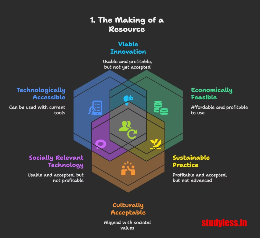
Q1. What are the three essential conditions for something in our environment to be termed as a ‘Resource’?
a) Technologically accessible, naturally abundant, and culturally valuable.
b) Environmentally friendly, economically viable, and socially equitable.
c) Technologically accessible, economically feasible, and culturally acceptable.
d) Globally recognized, historically significant, and politically stable.
Answer: c) Technologically accessible, economically feasible, and culturally acceptable.
Explanation: The definition of a ‘Resource’ explicitly states these three conditions: “Everything available in our environment which can be used to satisfy our needs, provided, it is technologically accessible, economically feasible and culturally acceptable can be termed as ‘Resource’”.
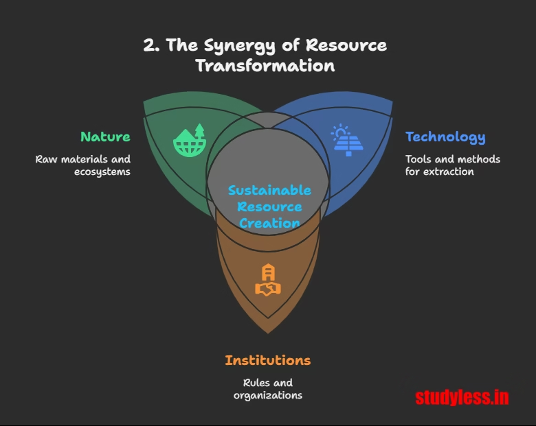
Q2. What is the interactive relationship involved in the process of transforming things available in our environment into resources?
a) Between society, economy, and politics.
b) Between nature, technology, and institutions.
c) Between land, water, and air.
d) Between producers, consumers, and distributors.
Answer: b) Between nature, technology, and institutions.
Explanation: The chapter states, “The process of transformation of things available in our environment involves an interactive relationship between nature, technology and institutions”.
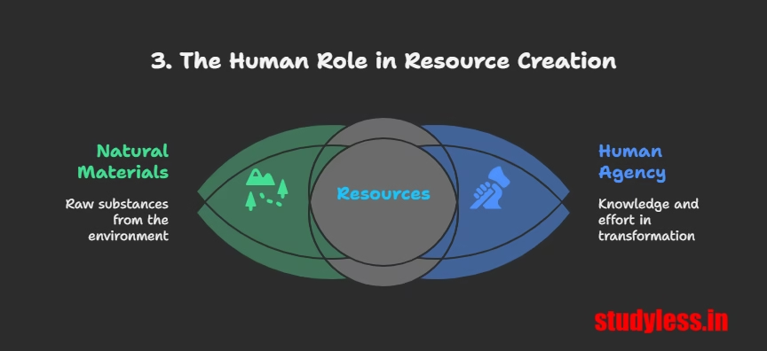
Q3. Why are resources NOT considered “free gifts of nature,” as assumed by many?
a) Because they are inherently scarce and limited.
b) Because human beings are essential components and transform materials into resources.
c) Because extracting them requires significant financial investment.
d) Because their distribution is often unequal among nations.
Answer: b) Because human beings are essential components and transform materials into resources.
Explanation: The chapter directly refutes the idea of resources being free gifts, stating, “They are not. Resources are a function of human activities. Human beings themselves are essential components of resources. They transform material available in our environment into resources and use them”.
Classification of Resources

Q4. Which of the following is NOT a basis for the classification of resources mentioned in the chapter ?
a) On the basis of origin.
b) On the basis of economic value.
c) On the basis of exhaustibility.
d) On the basis of ownership.
Answer: b) On the basis of economic value.
Explanation: The chapter – resource and development lists classifications based on origin (biotic/abiotic), exhaustibility (renewable/non-renewable), ownership (individual/community/national/international), and status of development (potential/developed stock/reserves). Economic value is not listed as a classification basis.
Development of Resources and Associated Problems
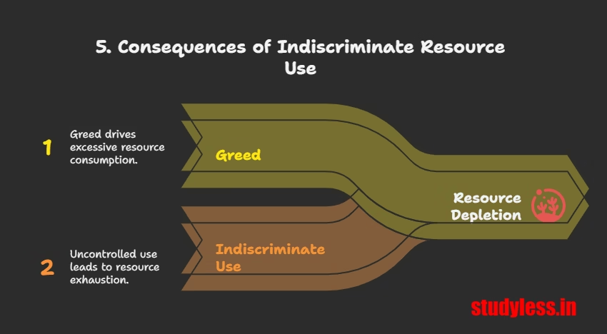
Q5. Which of the following is a major problem resulting from the indiscriminate use of resources, as highlighted in the chapter ?
a) Increased global trade and economic integration.
b) Depletion of resources for satisfying the greed of a few individuals.
c) Rapid technological advancements in resource extraction.
d) Equitable distribution of wealth among nations.
Answer: b) Depletion of resources for satisfying the greed of a few individuals.
Explanation: The chapter explicitly lists “Depletion of resources for satisfying the greed of a few individuals” as a major problem due to indiscriminate resource use.
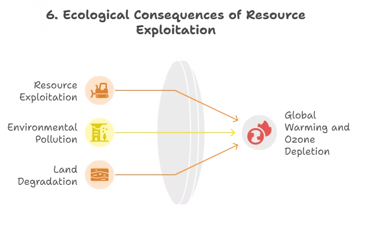
Q6. Indiscriminate exploitation of resources has led to which global ecological crisis?
a) Ocean acidification.
b) Biodiversity loss.
c) Global warming and ozone layer depletion.
d) Volcanic eruptions.
Answer: c) Global warming and ozone layer depletion.
Explanation: The chapter states that “Indiscriminate exploitation of resources has led to global ecological crises such as, global warming, ozone layer depletion, environmental pollution and land degradation”.

Q7. Why has equitable distribution of resources become essential?
a) To increase industrial productivity.
b) For a sustained quality of life and global peace.
c) To promote individual wealth accumulation.
d) To encourage competitive resource extraction.
Answer: b) For a sustained quality of life and global peace.
Explanation: The chapter emphasizes, “An equitable distribution of resources has become essential for a sustained quality of life and global peace”.
Sustainable Development
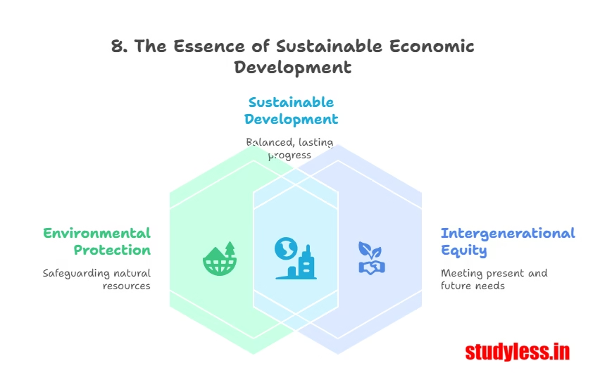
Q8. What is the core definition of Sustainable Economic Development?
a) Development that prioritizes economic growth above all else.
b) Development that ensures maximum resource extraction for immediate benefit.
c) Development that takes place without damaging the environment and does not compromise the needs of future generations.
d) Development that focuses solely on environmental protection, ignoring economic aspects.
Answer: c) Development that takes place without damaging the environment and does not compromise the needs of future generations.
Explanation: Sustainable economic development is defined as “development should take place without damaging the environment, and development in the present should not compromise with the needs of the future generations”.
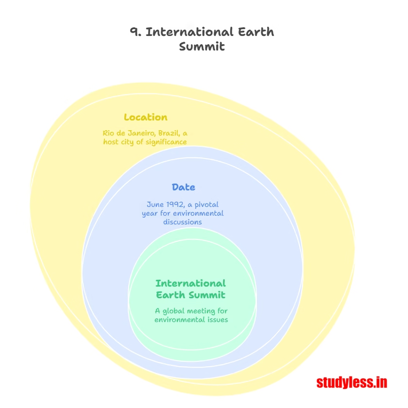
Q9. When and where was the first International Earth Summit held?
a) June 1987 in Brundtland.
b) June 1992 in Rio de Janeiro, Brazil.
c) March 1968 in Rome.
d) April 2000 in Johannesburg.
Answer: b) June 1992 in Rio de Janeiro, Brazil.
Explanation: The chapter states, “In June 1992, more than 100 heads of states met in Rio de Janeiro in Brazil, for the first International Earth Summit”.
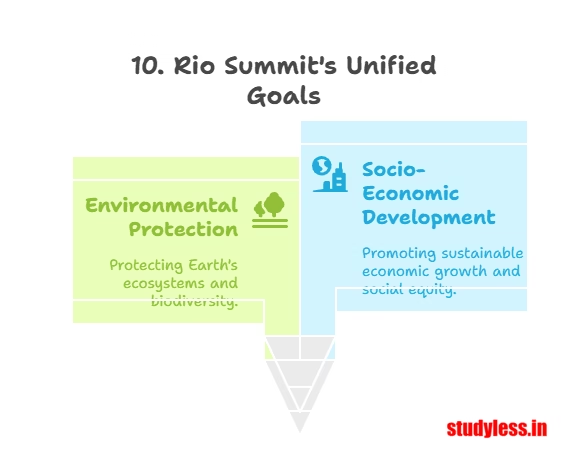
Q10. What was one of the main purposes for convening the Rio de Janeiro Earth Summit?
a) To establish new global trade agreements.
b) To address urgent problems of environmental protection and socio-economic development at the global level.
c) To form a new international economic organization.
d) To formalize treaties on arms control.
Answer: b) To address urgent problems of environmental protection and socio-economic development at the global level.
Explanation: The Summit “was convened for addressing urgent problems of environmental protection and socio-economic development at the global level”.
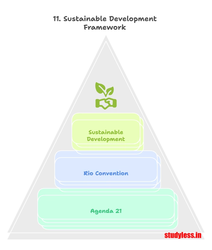
Q11. What key document was adopted at the Rio Earth Summit for achieving Sustainable Development in the 21st century?
a) The Kyoto Protocol.
b) The Paris Agreement.
c) Agenda 21.
d) The Millennium Development Goals.
Answer: c) Agenda 21.
Explanation: The Rio Convention “adopted Agenda 21 for achieving Sustainable Development in the 21st century”.
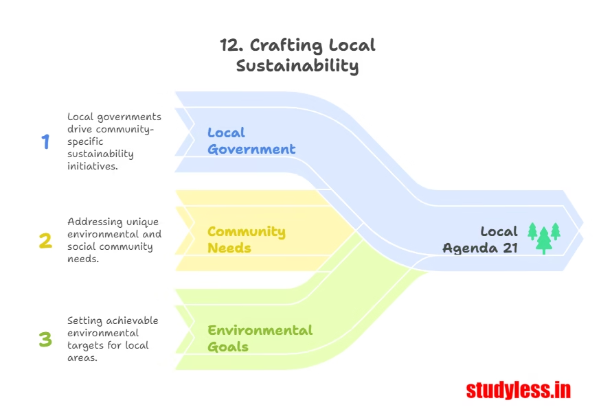
Q12. What is a major objective of Agenda 21 at the local level?
a) To establish international environmental courts.
b) That every local government should draw its own local Agenda 21.
c) To centralize all environmental decision-making.
d) To encourage individual rather than collective action on environmental issues.
Answer: b) That every local government should draw its own local Agenda 21.
Explanation: “One major objective of the Agenda 21 is that every local government should draw its own local Agenda 21”.
Resource Planning in India
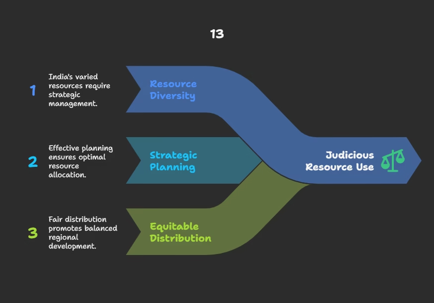
Q13. Why is resource planning considered an important strategy for judicious use of resources in a country like India?
a) Because India has a very uniform distribution of resources.
b) Because India has enormous diversity in the availability of resources.
c) Because India has very limited resources overall.
d) Because resource planning is not applicable to developing countries.
Answer: b) Because India has enormous diversity in the availability of resources.
Explanation: Resource planning “has importance in a country like India, which has enormous diversity in the availability of resources”.
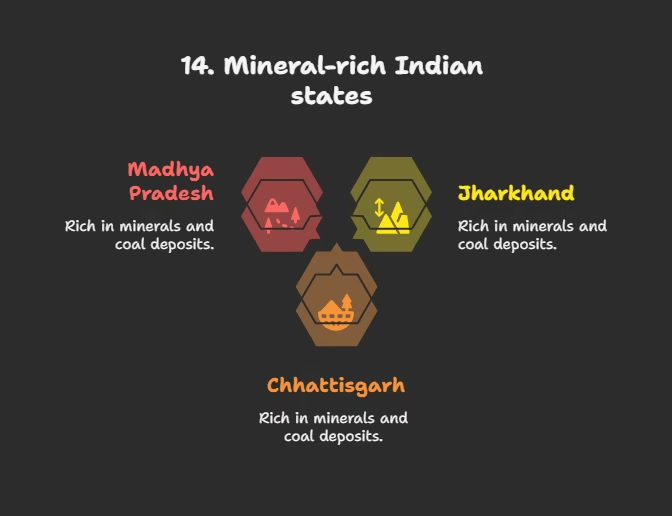
Q14. Which Indian states are cited as examples of being rich in minerals and coal deposits?
a) Punjab, Haryana, and Uttar Pradesh.
b) Jharkhand, Chhattisgarh, and Madhya Pradesh.
c) Rajasthan, Gujarat, and Maharashtra.
d) Arunachal Pradesh, Mizoram, and Manipur.
Answer: b) Jharkhand, Chhattisgarh, and Madhya Pradesh.
Explanation: The cahpter states, “For example, the states of Jharkhand, Chhattisgarh and Madhya Pradesh are rich in minerals and coal deposits”.
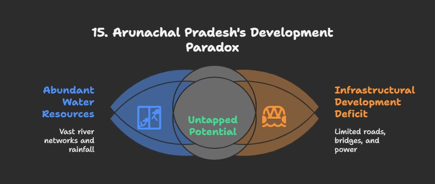
Q15. What resource is Arunachal Pradesh abundant in, but simultaneously deficient in?
a) Minerals; skilled labor.
b) Water resources; infrastructural development.
c) Solar energy; coal.
d) Forests; agricultural land.
Answer: b) Water resources; infrastructural development.
Explanation: “Arunachal Pradesh has abundance of water resources but lacks in infrastructural development”.

Q16. What is the state of Rajasthan particularly well endowed with, but lacking in?
a) Mineral wealth; forest cover.
b) Water resources; industrial development.
c) Solar and wind energy; water resources.
d) Agricultural land; population density.
Answer: c) Solar and wind energy; water resources.
Explanation: “The state of Rajasthan is very well endowed with solar and wind energy but lacks in water resources”.

Q17. What crucial factor, besides the availability of resources, contributes to development according to the chapter , particularly in India’s context?
a) Only the quantity of resources available.
b) Only political stability.
c) Technology, quality of human resources, and historical experiences.
d) Only the market demand for resources.
Answer: c) Technology, quality of human resources, and historical experiences.
Explanation: The chapter states, “Therefore, in India, development, in general, and resource development in particular does not only involve the availability of resources, but also the technology, quality of human resources and the historical experiences of the people”.
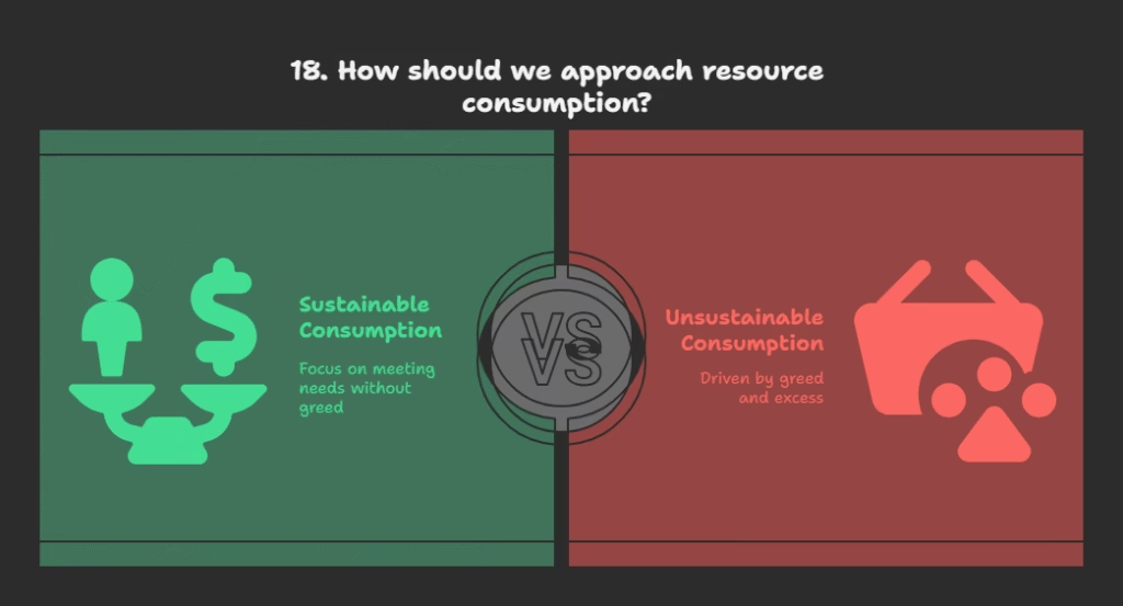
Q18. What was Gandhiji’s concern regarding resource consumption?
a) He advocated for mass production to satisfy all needs.
b) He believed in unlimited consumption as resources are abundant.
c) He said, “There is enough for everybody’s need and not for any body’s greed.”
d) He promoted the exploitation of resources through modern technology.
Answer: c) He said, “There is enough for everybody’s need and not for any body’s greed.”
Explanation: Gandhiji voiced his concern stating, “There is enough for everybody’s need and not for any body’s greed”.
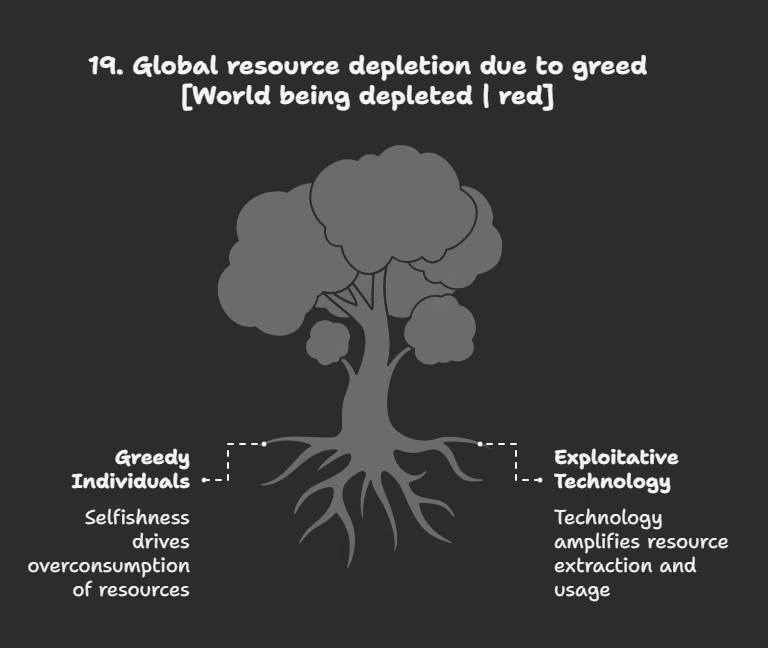
Q19. According to Gandhiji, what was the root cause for resource depletion at the global level?
a) Natural disasters and climate change.
b) Greedy and selfish individuals and exploitative nature of modern technology.
c) Lack of international cooperation.
d) Overpopulation in developing countries.
Answer: b) Greedy and selfish individuals and exploitative nature of modern technology.
Explanation: “He placed the greedy and selfish individuals and exploitative nature of modern technology as the root cause for resource depletion at the global level”.
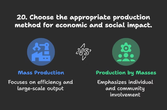
Q20. What was one of Gandhiji’s propositions regarding production?
a) Mass production for economic efficiency.
b) Production by the masses instead of mass production.
c) Production for export only.
d) Production limited to basic necessities.
Answer: b) Production by the masses instead of mass production.
Explanation: “He was against mass production and wanted to replace it with the production by the masses”.
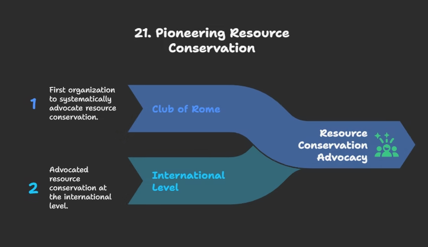
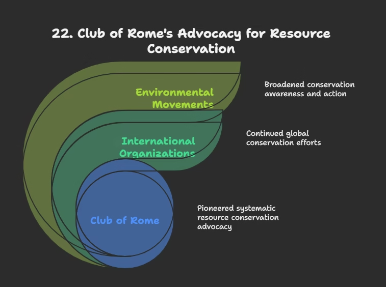
Q21. Which organization first advocated resource conservation in a systematic way in 1968?
a) The United Nations Environment Programme (UNEP).
b) The World Wildlife Fund (WWF).
c) The Club of Rome.
d) The Brundtland Commission.
Answer: c) The Club of Rome.
Explanation: “At the international level, the Club of Rome advocated resource conservation for the first time in a more systematic way in 1968”.
Q22. Which report made a seminal contribution to resource conservation at the global level by introducing the concept of ‘Sustainable Development’ in 1987?
a) The Rio Convention.
b) The Schumacher Report.
c) The Brundtland Commission Report.
d) The Agenda 21 document.
Answer: c) The Brundtland Commission Report.
Explanation: “The seminal contribution with respect to resource conservation at the global level was made by the Brundtland Commission Report, 1987. This report introduced the concept of ‘Sustainable Development’”.
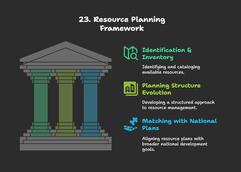
Q23. What are the three complex processes involved in resource planning in India?
a) Exploration, extraction, and distribution.
b) Identification & inventory, planning structure evolution, and matching with national plans.
c) Conservation, utilization, and recycling.
d) Taxation, regulation, and enforcement.
Answer: b) Identification & inventory, planning structure evolution, and matching with national plans.
Explanation: Resource planning “involves : (i) identification and inventory of resources… (ii) Evolving a planning structure… (iii) Matching the resource development plans with overall national development plans”.
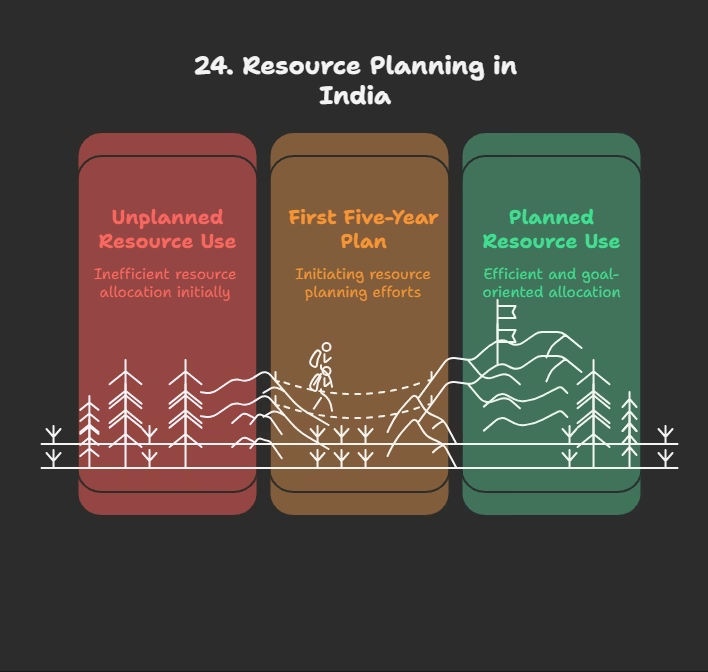
Q24. From which plan has India made concerted efforts for achieving the goals of resource planning?
a) From the first Five Year Plan launched after Independence.
b) From the time of the Green Revolution.
c) Since the Earth Summit in 1992.
d) Only in the last decade.
Answer: a) From the first Five Year Plan launched after Independence.
Explanation: “India has made concerted efforts for achieving the goals of resource planning right from the First Five Year Plan launched after Independence”.
Land Resources in India
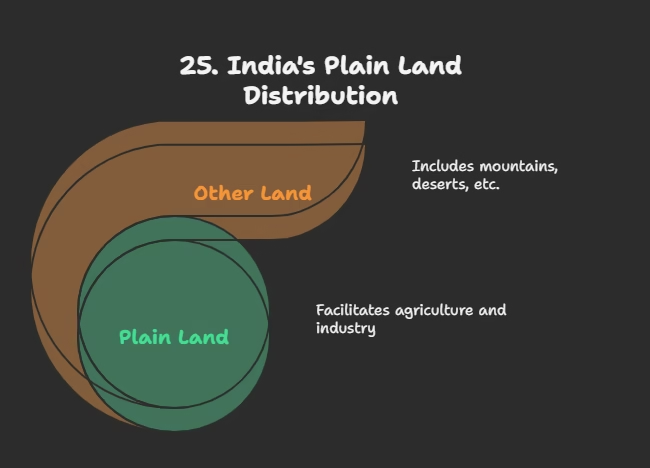
Q25. What percentage of India’s total geographical area is plain, providing facilities for agriculture and industry?
a) About 27 per cent.
b) About 30 per cent.
c) About 43 per cent.
d) About 54 per cent.
Answer: c) About 43 per cent.
Explanation: “About 43 per cent of the land area is plain, which provides facilities for agriculture and industry”.
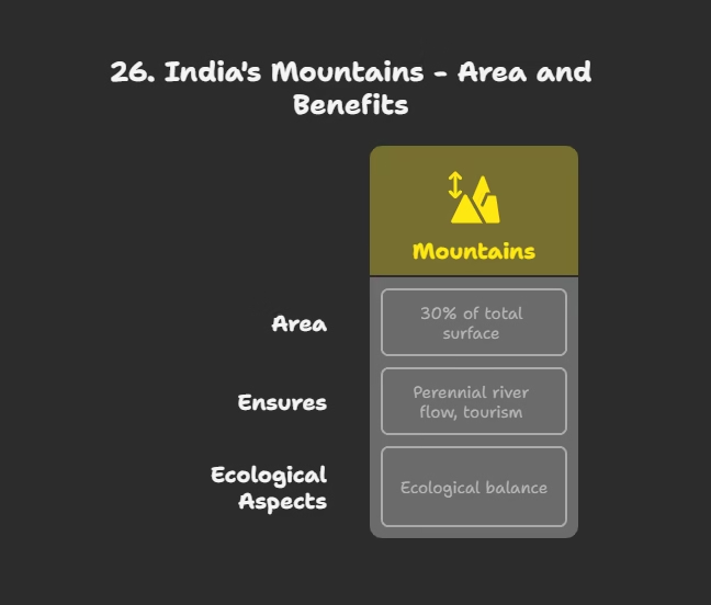
Q26. What percentage of India’s total surface area do mountains account for, and what do they ensure?
a) 27%; rich reserves of minerals.
b) 30%; perennial flow of some rivers and tourism facilities.
c) 43%; extensive agricultural land.
d) 54%; industrial development.
Answer: b) 30%; perennial flow of some rivers and tourism facilities.
Explanation: “Mountains account for 30 per cent of the total surface area of the country and ensure perennial flow of some rivers, provide facilities for tourism and ecological aspects”.
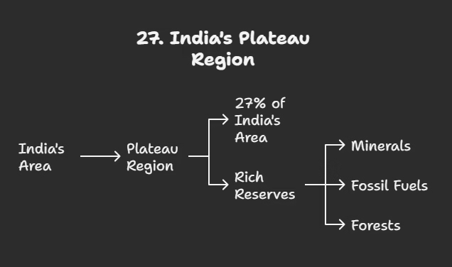
Q27. What percentage of India’s area is the plateau region, and what does it possess?
a) 43%; facilities for agriculture and industry.
b) 30%; perennial flow of rivers.
c) 27%; rich reserves of minerals, fossil fuels, and forests.
d) 54%; high population density.
Answer: c) 27%; rich reserves of minerals, fossil fuels, and forests.
Explanation: “About 27 per cent of the area of the country is the plateau region. It possesses rich reserves of minerals, fossil fuels and forests”.
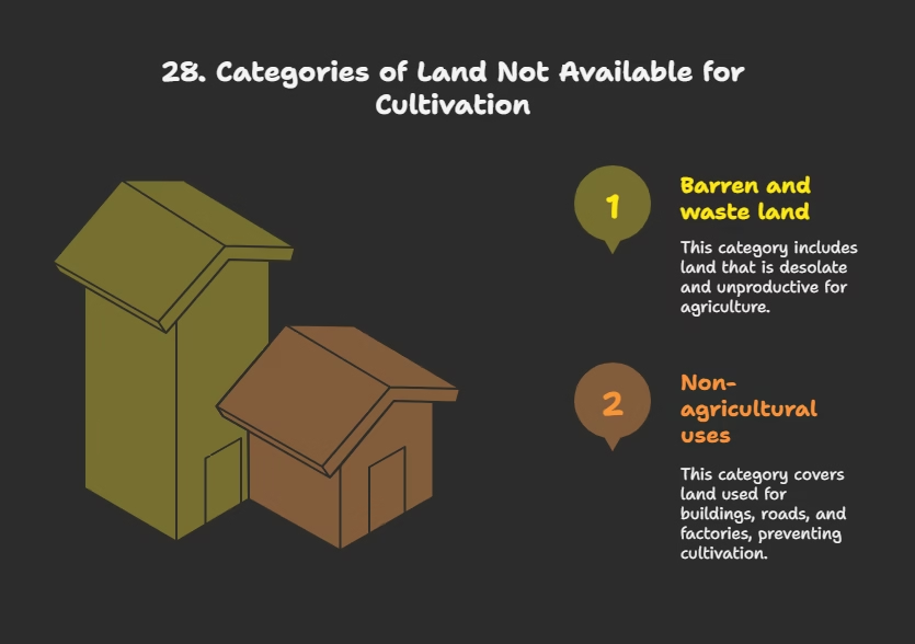
Q28. Which of the following is NOT listed as a category under “Land not available for cultivation”?
a) Barren and waste land.
b) Land under miscellaneous tree crops groves.
c) Land put to non-agricultural uses (e.g., buildings, roads, factories).
d) None of the above (all are listed).
Answer: b) Land under miscellaneous tree crops groves.
Explanation: Land under miscellaneous tree crops groves is classified under “Other uncultivated land (excluding fallow land),” not “Land not available for cultivation”.

Q29. What is ‘Current fallow’ land defined as?
a) Land left uncultivated for more than 5 agricultural years.
b) Land left without cultivation for one or less than one agricultural year.
c) Land used for permanent pastures and grazing.
d) Land used for non-agricultural purposes like buildings and roads.
Answer: b) Land left without cultivation for one or less than one agricultural year.
Explanation: “Current fallow-(left without cultivation for one or less than one agricultural year)”.
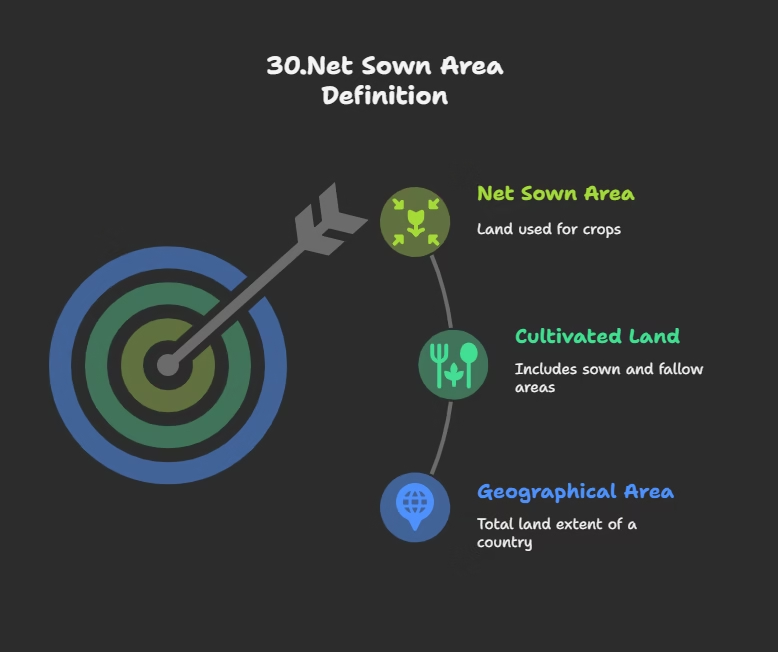
Q30. What is the definition of ‘Net sown area’?
a) The total geographical area of the country.
b) The physical extent of land on which crops are sown and harvested.
c) Area sown more than once in an agricultural year.
d) All cultivated land including fallow lands.
Answer: b) The physical extent of land on which crops are sown and harvested.
Explanation: “Net sown area– the physical extent of land on which crops are sown harvested is known as net sown area”.
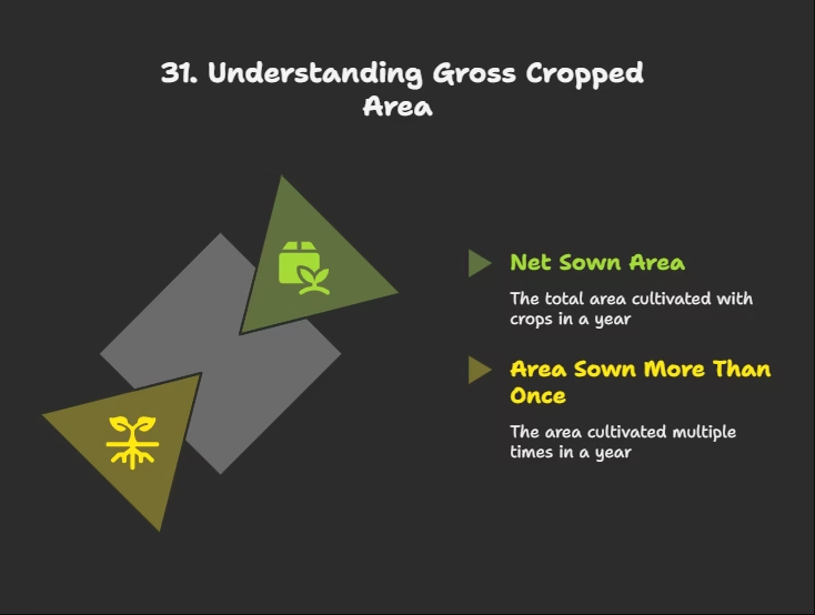
Q31. What is ‘gross cropped area’?
a) The net sown area only.
b) Area sown more than once in an agricultural year plus net sown area.
c) Total agricultural land including barren land.
d) Land under permanent pastures and groves.
Answer: b) Area sown more than once in an agricultural year plus net sown area.
Explanation: “Area sown more than once in an agricultural year plus net sown area is known as gross cropped area”.
Land Utilization and Land Use Pattern
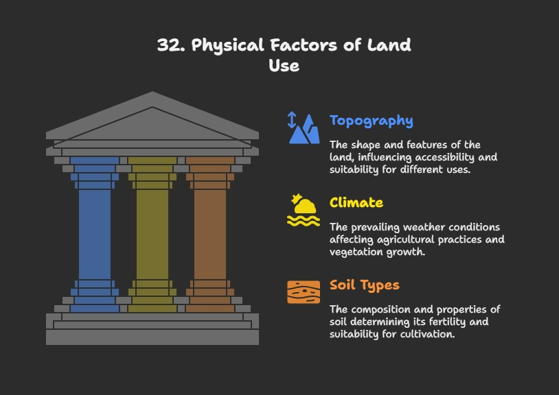
Q32. Which of the following is NOT a physical factor determining land use in India?
a) Topography.
b) Climate.
c) Soil types.
d) Population density.
Answer: d) Population density.
Explanation: Population density is listed as a ‘human factor’, while topography, climate, and soil types are ‘physical factors’.
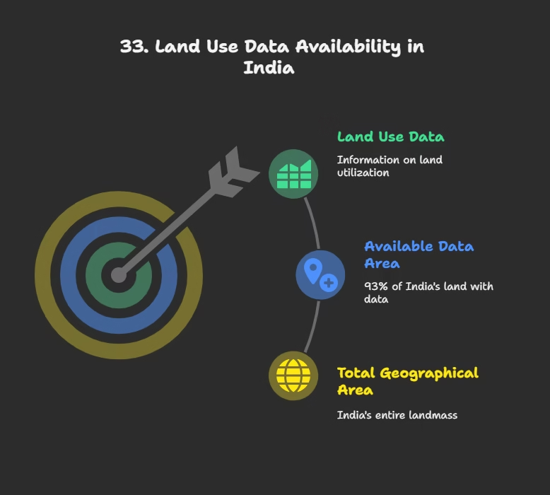
Q33. What is the total geographical area of India for which land use data is available?
a) 3.28 million sq km.
b) 93 per cent of the total geographical area.
c) Only the cultivated areas.
d) Data is available for 100 per cent of the area.
Answer: b) 93 per cent of the total geographical area.
Explanation: “Land use data, however, is available only for 93 per cent of the total geographical area”. The total geographical area of India is 3.28 million sq km, but data isn’t fully available for all of it.
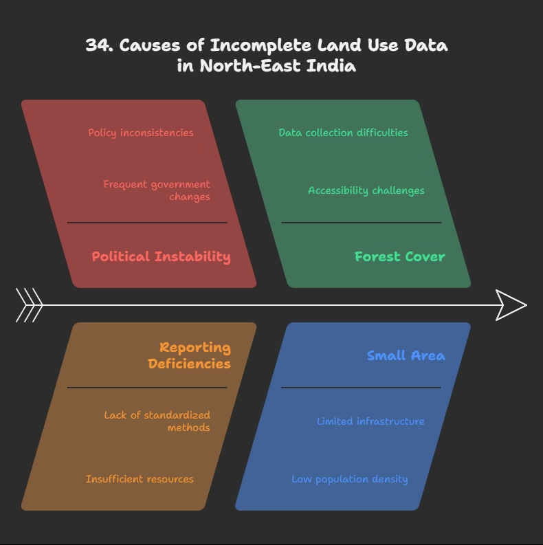
Q34. Why is land use data not fully available for most of the north-east states except Assam?
a) Due to political instability.
b) Land use reporting has not been done fully.
c) Because these areas are mostly covered by forests.
d) They are very small in terms of area.
Answer: b) Land use reporting has not been done fully.
Explanation: “land use reporting for most of the north-east states except Assam has not been done fully”.
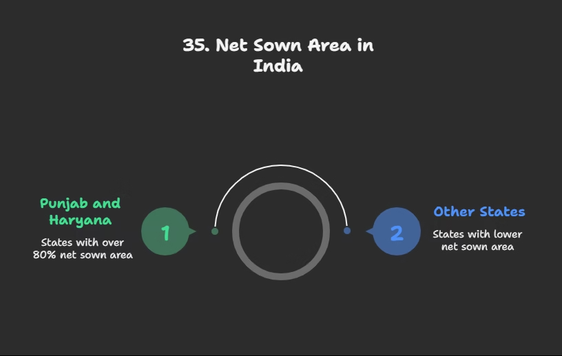
Q35. In which Indian states is the net sown area over 80% of the total area?
a) Arunachal Pradesh, Mizoram, Manipur.
b) Jharkhand, Chhattisgarh, Madhya Pradesh.
c) Punjab and Haryana.
d) Rajasthan and Gujarat.
Answer: c) Punjab and Haryana.
Explanation: “It is over 80 per cent of the total area in Punjab and Haryana”.
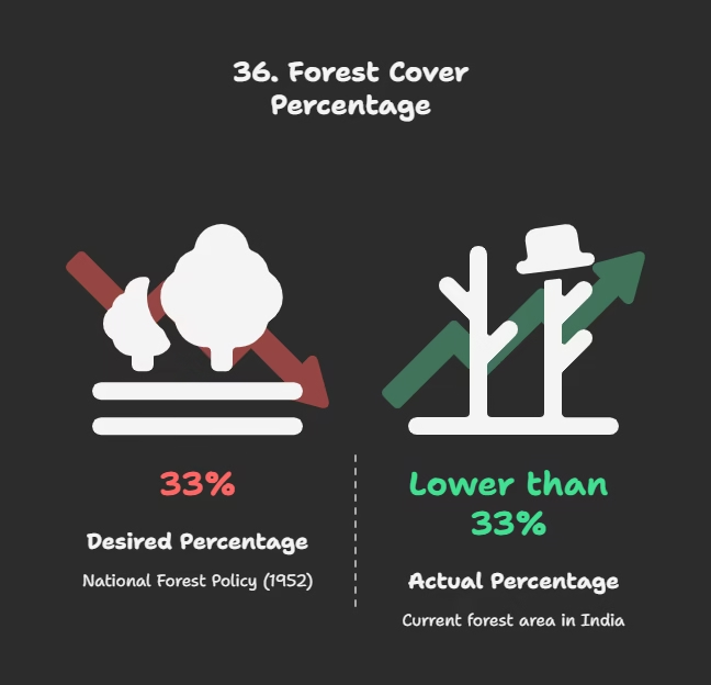
Q36. The forest area in India is far lower than the desired percentage outlined in the National Forest Policy (1952). What was the desired percentage?
a) 27 per cent.
b) 30 per cent.
c) 33 per cent.
d) 43 per cent.
Answer: c) 33 per cent.
Explanation: “Forest area in the country is far lower than the desired 33 per cent of geographical area, as it was outlined in the National Forest Policy (1952)”.
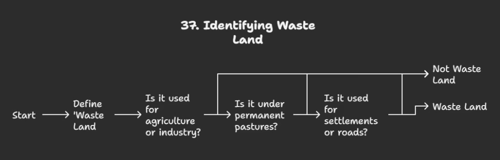
Q37. What is ‘waste land’ mentioned in the context of land use?
a) Land used for agriculture and industry.
b) Land under permanent pastures.
c) Land that includes rocky, arid, and desert areas.
d) Land used for settlements and roads.
Answer: c) Land that includes rocky, arid, and desert areas.
Explanation: “Waste land includes rocky, arid and desert areas”.

Q38. What does “land put to other non-agricultural uses” include?
a) Culturable waste land and fallow land.
b) Permanent pastures and grazing land.
c) Settlements, roads, railways, industry etc.
d) Forests and mountains.
Answer: c) Settlements, roads, railways, industry etc.
Explanation: “land put to other non-agricultural uses includes settlements, roads, railways, industry etc.”.
Conservation of Resources
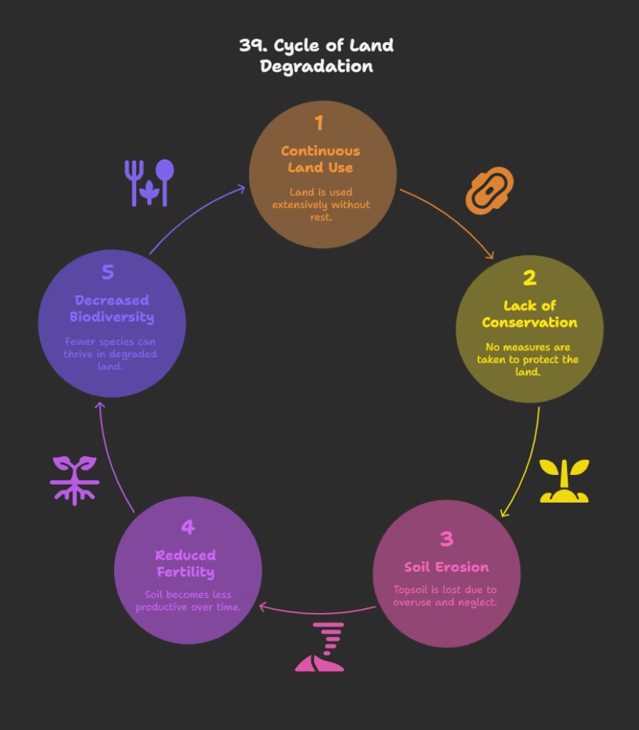
Q39. What has resulted from the continuous use of land over a long period without appropriate conservation and management measures?
a) Increased soil fertility.
b) Expansion of forest cover.
c) Land degradation.
d) Enhanced biodiversity.
Answer: c) Land degradation.
Explanation: “Continuous use of land over a long period of time without taking appropriate measures to conserve and manage it, has resulted in land degradation”.
Q40. What percentage of our basic needs for food, shelter, and clothing are obtained from land?
a) About 50 per cent.
b) About 75 per cent.
c) Ninety-five per cent.
d) All of our basic needs.
Answer: c) Ninety-five per cent.
Explanation: “Ninety-five per cent of our basic needs for food, shelter and clothing are obtained from land”.
Land Degradation and Conservation Measures
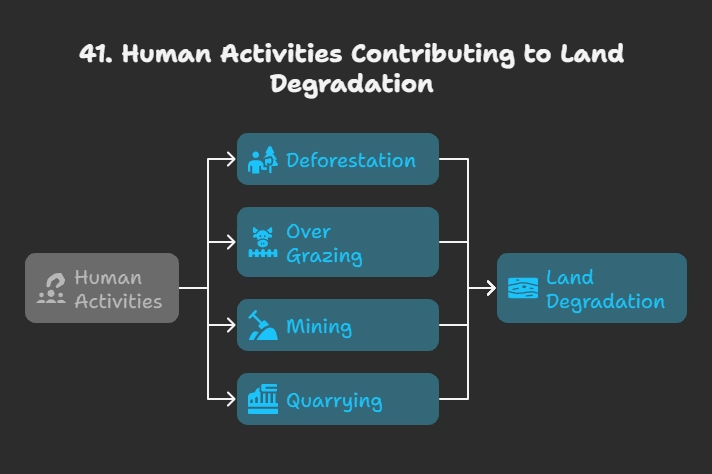
Q41. Which of the following human activities is listed as significantly contributing to land degradation?
a) Reforestation.
b) Sustainable farming practices.
c) Deforestation, over grazing, mining, and quarrying.
d) Development of national parks.
Answer: c) Deforestation, over grazing, mining, and quarrying.
Explanation: “Some human activities such as deforestation, over grazing, mining and quarrying too have contributed significantly in land degradation”.
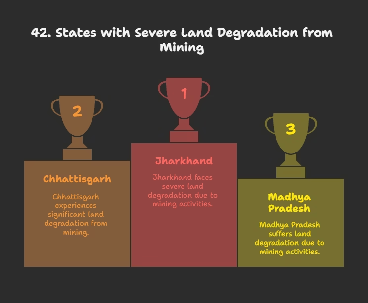
Q42. In which states has deforestation due to mining caused severe land degradation?
a) Punjab, Haryana, Uttar Pradesh.
b) Gujarat, Rajasthan, Madhya Pradesh.
c) Jharkhand, Chhattisgarh, Madhya Pradesh, and Odisha.
d) Karnataka, Kerala, and Tamil Nadu.
Answer: c) Jharkhand, Chhattisgarh, Madhya Pradesh, and Odisha.
Explanation: “In states like Jharkhand, Chhattisgarh, Madhya Pradesh and Odisha deforestation due to mining have caused severe land degradation”.
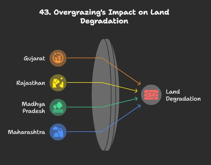
Q43. Overgrazing is one of the main reasons for land degradation in which group of states?
a) Punjab, Haryana, western Uttar Pradesh.
b) Gujarat, Rajasthan, Madhya Pradesh, and Maharashtra.
c) Jharkhand, Chhattisgarh, and Odisha.
d) Karnataka, Kerala, and Tamil Nadu.
Answer: b) Gujarat, Rajasthan, Madhya Pradesh, and Maharashtra.
Explanation: “In states like Gujarat, Rajasthan, Madhya Pradesh and Maharashtra overgrazing is one of the main reasons for land degradation”.
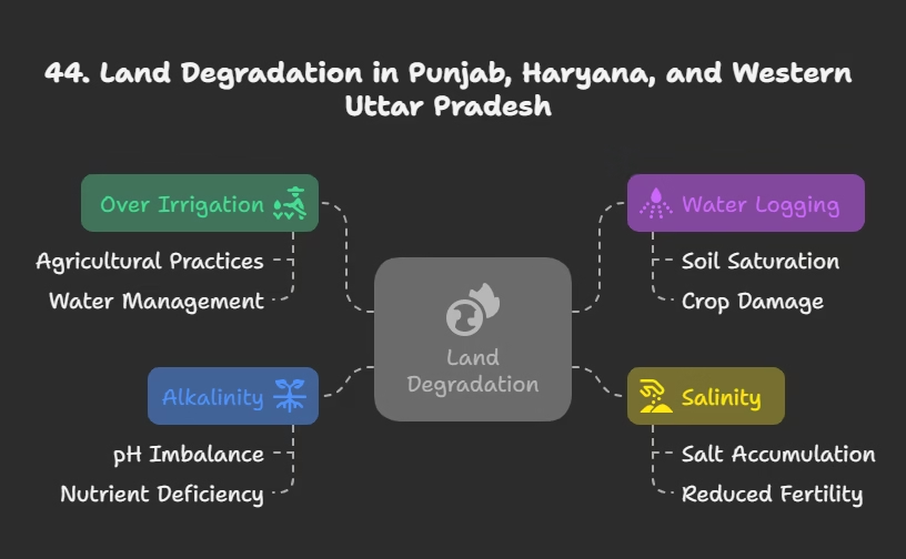
Q44. What is the main cause of land degradation in Punjab, Haryana, and western Uttar Pradesh?
a) Deforestation.
b) Mining activities.
c) Over irrigation leading to water logging, salinity, and alkalinity.
d) Excessive use of fertilizers.
Answer: c) Over irrigation leading to water logging, salinity, and alkalinity.
Explanation: “In the states of Punjab, Haryana, western Uttar Pradesh, over irrigation is responsible for land degradation due to water logging leading to increase in salinity and alkalinity in the soil”.

Q45. How does mineral processing, like grinding limestone for cement industry, contribute to land degradation?
a) It consumes large amounts of water, leading to drought.
b) It generates huge quantities of dust, which retards water infiltration into the soil.
c) It directly removes topsoil.
d) It contaminates groundwater.
Answer: b) It generates huge quantities of dust, which retards water infiltration into the soil.
Explanation: “The mineral processing like grinding of limestone for cement industry… generate huge quantity of dust in the atmosphere. It retards the process of infiltration of water into the soil after it settles down on the land”.
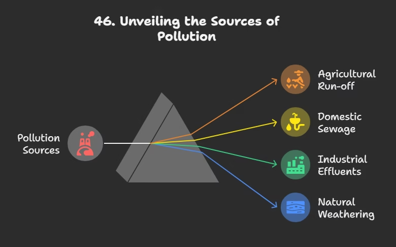
Q46. What has become a major source of land and water pollution in many parts of the country in recent years?
a) Agricultural run-off.
b) Domestic sewage.
c) Industrial effluents as waste.
d) Natural weathering processes.
Answer: c) Industrial effluents as waste.
Explanation: “In recent years, industrial effluents as waste have become a major source of land and water pollution in many parts of the country”.
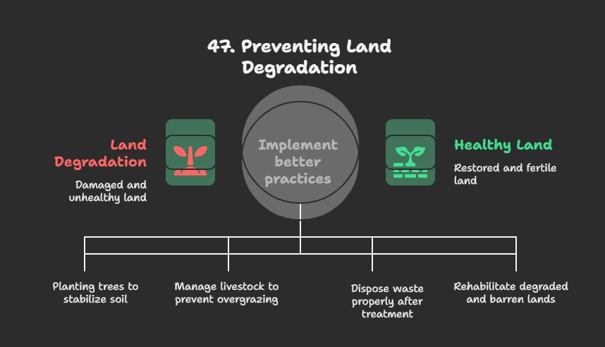
Q47. Which of the following is NOT suggested as a measure to solve land degradation problems?
a) Afforestation.
b) Control on over grazing.
c) Indiscriminate dumping of industrial waste.
d) Proper management of waste lands.
Answer: c) Indiscriminate dumping of industrial waste.
Explanation: The chapter suggests “proper discharge and disposal of industrial effluents and wastes after treatment,” which is the opposite of indiscriminate dumping.
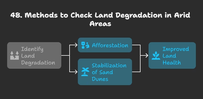
Q48. What methods are suggested to check land degradation in arid areas?
a) Over irrigation and intensive cultivation.
b) Afforestation and stabilization of sand dunes by growing thorny bushes.
c) Industrial development and urbanization.
d) Mining and quarrying.
Answer: b) Afforestation and stabilization of sand dunes by growing thorny bushes.
Explanation: “Afforestation and proper management of grazing can help to some extent. Planting of shelter belts of plants, control on over grazing, stabilization of sand dunes by growing thorny bushes are some of the methods to check land degradation in arid areas”.
Soil as a Resource and Soil Formation
Q49. What is soil described as in the cahpter?
a) A non-renewable natural resource.
b) A static geological formation.
c) The most important renewable natural resource and a living system.
d) A simple mixture of rock particles.
Answer: c) The most important renewable natural resource and a living system.
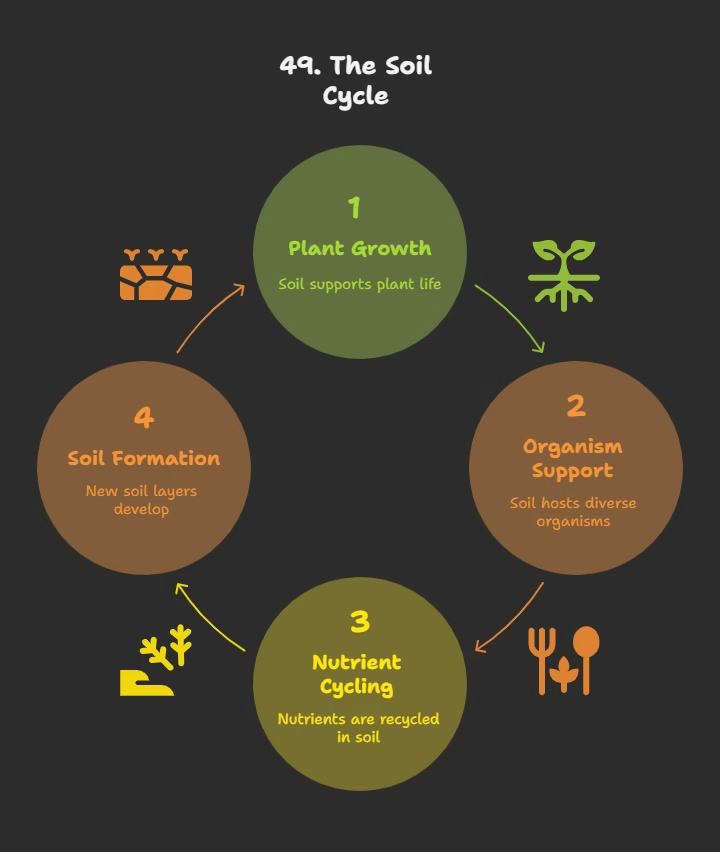
Explanation: “Soil is the most important renewable natural resource. It is the medium of plant growth and supports different types of living organisms on the earth. The soil is a living system”.
Q50. What is the approximate time it takes to form soil up to a few cm in depth?
a) A few days.
b) A few years.
c) Hundreds of years.
d) Millions of years.
Answer: d) Millions of years.
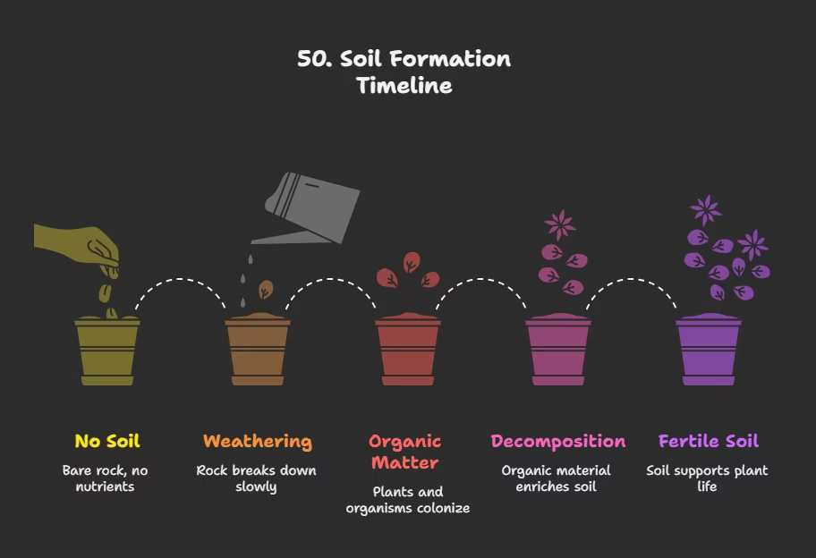
Explanation: “It takes millions of years to form soil up to a few cm in depth”.
Q51. Which of the following is NOT an important factor in the formation of soil?
a) Relief and parent rock.
b) Climate and vegetation.
c) Industrial pollution.
d) Other forms of life and time.
Answer: c) Industrial pollution.
Explanation: Relief, parent rock or bed rock, climate, vegetation and other forms of life and time are important factors in the formation of soil. Industrial pollution is a cause of soil degradation, not formation.
Q52. What contributes to the formation of soil through various forces of nature?
a) Volcanic eruptions and earthquakes.
b) Change in temperature, actions of running water, wind, and glaciers.
c) Human construction activities.
d) Solar flares and meteors.
Answer: b) Change in temperature, actions of running water, wind, and glaciers.
Explanation: Various forces of nature such as change in temperature, actions of running water, wind and glaciers, activities of decomposers etc. contribute to the formation of soil.
Q53. Besides organic (humus) and inorganic materials, what changes are also important in soil?
a) Physical and magnetic changes.
b) Chemical and organic changes.
c) Electrical and thermal changes.
d) Atmospheric and lunar changes.
Answer: b) Chemical and organic changes.
Explanation: Chemical and organic changes which take place in the soil are equally important. Soil also consists of organic (humus) and inorganic materials.
Classification and Types of Soils in India
Q54. What factors are used to classify the soils of India into different types?
a) Only depth and moisture content.
b) Color, thickness, texture, age, chemical and physical properties, and factors responsible for soil formation.
c) Only vegetation type and rainfall.
d) Economic utility and accessibility.
Answer: b) Color, thickness, texture, age, chemical and physical properties, and factors responsible for soil formation.
Explanation: On the basis of the factors responsible for soil formation, colour, thickness, texture, age, chemical and physical properties, the soils of India are classified in different types.
Q55. Which soil type is the most widely spread and important, forming the entire northern plains of India?
a) Black soil.
b) Red and Yellow soil.
c) Laterite soil.
d) Alluvial soil.
Answer: d) Alluvial soil.
Explanation: This is the most widely spread and important soil. In fact, the entire northern plains are made of alluvial soil.
Q56. Which three important Himalayan river systems have deposited the alluvial soils in the northern plains?
a) Narmada, Tapi, and Mahanadi.
b) Godavari, Krishna, and Kaveri.
c) Indus, Ganga, and Brahmaputra.
d) Yamuna, Chambal, and Betwa.
Answer: c) Indus, Ganga, and Brahmaputra.
Explanation: These have been deposited by three important Himalayan river systems – the Indus, the Ganga and the Brahmaputra.
Q57. Alluvial soil is also found in the eastern coastal plains, particularly in the deltas of which rivers?
a) Indus, Ganga, and Brahmaputra.
b) Mahanadi, Godavari, Krishna, and Kaveri.
c) Narmada and Tapi.
d) Sabarmati and Mahi.
Answer: b) Mahanadi, Godavari, Krishna, and Kaveri.
Explanation: Alluvial soil is also found in the eastern coastal plains particularly in the deltas of the Mahanadi, the Godavari, the Krishna and the Kaveri rivers.
Q58. As one moves inland towards the river valleys in alluvial soil regions, what happens to the soil particles?
a) They appear smaller in size.
b) They appear somewhat bigger in size.
c) Their size remains uniform.
d) They become finer.
Answer: b) They appear somewhat bigger in size.
Explanation: As we move inlands towards the river valleys, soil particles appear somewhat bigger in size.
Q59. What are the coarse alluvial soils near the place of the break of slope in upper river reaches called?
a) Bhangar.
b) Khadar.
c) Piedmont plains such as Duars, Chos, and Terai.
d) Deltaic soils.
Answer: c) Piedmont plains such as Duars, Chos, and Terai.
Explanation: Such soils are more common in piedmont plains such as Duars, Chos and Terai.
Q60. On the basis of age, what are the two classifications of alluvial soils?
a) Coarse and fine.
b) Sandy and clayey.
c) Old alluvial (Bangar) and new alluvial (Khadar).
d) Humus rich and humus poor.
Answer: c) Old alluvial (Bangar) and new alluvial (Khadar).
Explanation: According to their age alluvial soils can be classified as old alluvial (Bangar) and new alluvial (Khadar).
Q61. Which type of alluvial soil has a higher concentration of kanker nodules and is less fertile?
a) Khadar.
b) Bangar.
c) Terai.
d) Deltaic.
Answer: b) Bangar.
Explanation: The bangar soil has higher concentration of kanker nodules than the Khadar. The chapter implies Bangar is less fertile because Khadar is more fertile than Bangar.
Q62. Which type of alluvial soil has more fine particles and is more fertile?
a) Bangar.
b) Khadar.
c) Piedmont.
d) Duars.
Answer: b) Khadar.
Explanation: Khadar has more fine particles and is more fertile than the Bangar.
Q63. What proportion of nutrients do alluvial soils mostly contain, making them ideal for crops like sugarcane, paddy, and wheat?
a) Low nitrogen and high potash.
b) Adequate proportion of potash, phosphoric acid, and lime.
c) Only calcium and magnesium.
d) High iron and low organic matter.
Answer: b) Adequate proportion of potash, phosphoric acid, and lime.
Explanation: Mostly these soils contain adequate proportion of potash, phosphoric acid and lime which are ideal for the growth of sugarcane, paddy, wheat and other cereal and pulse crops.
Q64. Why are regions of alluvial soils intensively cultivated and densely populated?
a) Because they are found near urban centers.
b) Due to their high fertility.
c) Because they are easy to access.
d) Due to abundant water resources.
Answer: b) Due to their high fertility.
Explanation: Due to its high fertility, regions of alluvial soils are intensively cultivated and densely populated.
Q65. What are Black Soils also known as?
a) Laterite soils.
b) Arid soils.
c) Regur soils.
d) Alluvial soils.
Answer: c) Regur soils.
Explanation: These soils are black in colour and are also known as regur soils.
Q66. Which crop is Black Soil considered ideal for growing?
a) Sugarcane.
b) Paddy.
c) Cotton.
d) Wheat.
Answer: c) Cotton.
Explanation: Black soil is ideal for growing cotton and is also known as black cotton soil.
Q67. What are the important factors for the formation of black soil?
a) Relief and vegetation.
b) Climatic condition along with the parent rock material.
c) Water availability and human activities.
d) Wind erosion and temperature changes.
Answer: b) Climatic condition along with the parent rock material.
Explanation: It is believed that climatic condition along with the parent rock material are the important factors for the formation of black soil.
Q68. The black soil is typical of which geological region and is made up of what?
a) Himalayan region; sedimentary rocks.
b) Eastern Ghats; metamorphic rocks.
c) Deccan trap (Basalt) region; lava flows.
d) Coastal plains; alluvial deposits.
Answer: c) Deccan trap (Basalt) region; lava flows.
Explanation: This type of soil is typical of the Deccan trap (Basalt) region spread over northwest Deccan plateau and is made up of lava flows.
Q69. Black soils cover the plateaus of which Indian states?
a) Punjab, Haryana, Uttar Pradesh.
b) Maharashtra, Saurashtra, Malwa, Madhya Pradesh, and Chhattisgarh.
c) Jharkhand, Odisha, and West Bengal.
d) Karnataka, Kerala, and Tamil Nadu.
Answer: b) Maharashtra, Saurashtra, Malwa, Madhya Pradesh, and Chhattisgarh.
Explanation: They cover the plateaus of Maharashtra, Saurashtra, Malwa, Madhya Pradesh and Chhattisgarh.
Q70. What characteristic are black soils well-known for?
a) Their capacity to hold moisture.
b) Their rapid drainage.
c) Their sandy texture.
d) Their high acidity.
Answer: a) Their capacity to hold moisture.
Explanation: They are well-known for their capacity to hold moisture.
Q71. Black soils are rich in which soil nutrients?
a) Nitrogen and potassium.
b) Calcium carbonate, magnesium, potash, and lime.
c) Phosphoric contents.
d) Iron and aluminum.
Answer: b) Calcium carbonate, magnesium, potash, and lime.
Explanation: In addition, they are rich in soil nutrients, such as calcium carbonate, magnesium, potash and lime.
Q72. What feature do black soils develop during hot weather, helping in aeration?
a) A hard crust.
b) Deep cracks.
c) Waterlogging.
d) Salt deposits.
Answer: b) Deep cracks.
Explanation: They develop deep cracks during hot weather, which helps in the proper aeration of the soil.
Q73. Why are black soils difficult to work on unless tilled immediately after the first shower or during the pre-monsoon period?
a) Because they become too dry and hard.
b) Because they become sticky when wet.
c) Because they are prone to wind erosion.
d) Because they lack sufficient nutrients.
Answer: b) Because they become sticky when wet.
Explanation: These soils are sticky when wet and difficult to work on unless tilled immediately after the first shower or during the pre-monsoon period.
Q74. Red soil develops on which type of rocks and in what rainfall conditions?
a) Sedimentary rocks in areas of high rainfall.
b) Crystalline igneous rocks in areas of low rainfall.
c) Metamorphic rocks in arid conditions.
d) Volcanic rocks in coastal areas.
Answer: b) Crystalline igneous rocks in areas of low rainfall.
Explanation: Red soil develops on crystalline igneous rocks in areas of low rainfall in the eastern and southern parts of the Deccan plateau.
Q75. What causes Red and Yellow soils to develop a reddish colour?
a) High clay content.
b) Diffusion of iron in crystalline and metamorphic rocks.
c) Abundant organic matter.
d) Presence of copper deposits.
Answer: b) Diffusion of iron in crystalline and metamorphic rocks.
Explanation: These soils develop a reddish colour due to diffusion of iron in crystalline and metamorphic rocks.
Q76. When does Red and Yellow soil look yellow?
a) When it is dry.
b) When it is exposed to sunlight.
c) When it occurs in a hydrated form.
d) When it is mixed with organic matter.
Answer: c) When it occurs in a hydrated form.
Explanation: It looks yellow when it occurs in a hydrated form.
Q77. The term ‘Laterite’ is derived from a Latin word meaning what?
a) Soil.
b) Water.
c) Brick.
d) Earth.
Answer: c) Brick.
Explanation: Laterite has been derived from the Latin word ‘later’ which means brick.
Q78. Under what climatic conditions does laterite soil develop?
a) Arid and semi-arid climates.
b) Temperate climates with moderate rainfall.
c) Tropical and subtropical climate with alternate wet and dry season.
d) Cold climates with snow cover.
Answer: c) Tropical and subtropical climate with alternate wet and dry season.
Explanation: The laterite soil develops under tropical and subtropical climate with alternate wet and dry season.
Q79. What is the result of intense leaching due to heavy rain in the formation of laterite soils?
a) High fertility.
b) Accumulation of plant nutrients.
c) Soil becomes very deep and acidic (pH<6.0).
d) Development of Kankar layers.
Answer: c) Soil becomes very deep and acidic (pH<6.0).
Explanation: This soil is the result of intense leaching due to heavy rain. Lateritic soils are mostly deep to very deep, acidic (pH<6.0), generally deficient in plant nutrients.
Q80. In which regions are lateritic soils mostly found?
a) Northern plains and central highlands.
b) Southern states, Western Ghats region of Maharashtra, Odisha, parts of West Bengal, and North-east regions.
c) Deserts of Rajasthan and Gujarat.
d) Himalayan snow-covered areas.
Answer: b) Southern states, Western Ghats region of Maharashtra, Odisha, parts of West Bengal, and North-east regions.
Explanation: Lateritic soils occur mostly in southern states, Western Ghats region of Maharashtra, Odisha, some parts of West Bengal and North-east regions.
Q81. For which crops is laterite soil very useful, particularly in the hilly areas of Karnataka, Kerala, and Tamil Nadu, after adopting appropriate soil conservation techniques?
a) Sugarcane and paddy.
b) Wheat and pulses.
c) Tea and coffee.
d) Cotton and cereals.
Answer: c) Tea and coffee.
Explanation: After adopting appropriate soil conservation techniques, particularly in the hilly areas of Karnataka, Kerala and Tamil Nadu, this soil is very useful for growing tea and coffee.
Q82. Which crop is suitable for Red laterite soils in Tamil Nadu, Andhra Pradesh, and Kerala?
a) Rice.
b) Wheat.
c) Cashew nut.
d) Grapes.
Answer: c) Cashew nut.
Explanation: Red laterite soils in Tamil Nadu, Andhra Pradesh and Kerala are more suitable for crops like cashew nut.
Q83. What is the typical texture and nature of Arid soils?
a) Clayey and acidic.
b) Loamy and fertile.
c) Sandy in texture and saline in nature.
d) Silt and humus rich.
Answer: c) Sandy in texture and saline in nature.
Explanation: Arid soils range from red to brown in colour. They are generally sandy in texture and saline in nature.
Q84. Why do arid soils lack humus and moisture?
a) Due to high rainfall.
b) Due to the dry climate, high temperature, and faster evaporation.
c) Due to extensive cultivation.
d) Due to the presence of Kankar layers.
Answer: b) Due to the dry climate, high temperature, and faster evaporation.
Explanation: Due to the dry climate, high temperature, evaporation is faster and the soil lacks humus and moisture.
Q85. What restricts the infiltration of water in the lower horizons of arid soils?
a) High clay content.
b) Presence of sand dunes.
c) Kankar layer formations because of increasing calcium content downwards.
d) Absence of vegetation.
Answer: c) Kankar layer formations because of increasing calcium content downwards.
Explanation: The lower horizons of the soil are occupied by Kankar because of the increasing calcium content downwards. The Kankar layer formations in the bottom horizons restrict the infiltration of water.
Q86. How can arid soils become cultivable, as seen in western Rajasthan?
a) Through afforestation.
b) After proper irrigation.
c) By adding organic matter.
d) By reducing salt content naturally.
Answer: b) After proper irrigation.
Explanation: After proper irrigation these soils become cultivable as has been in the case of western Rajasthan.
Q87. Where are Forest Soils typically found?
a) In desert areas.
b) In coastal plains.
c) In the hilly and mountainous areas where sufficient rain forests are available.
d) In river deltas.
Answer: c) In the hilly and mountainous areas where sufficient rain forests are available.
Explanation: These soils are found in the hilly and mountainous areas where sufficient rain forests are available.
Q88. What is the texture of forest soils in valley sides and upper slopes?
a) Sandy in valley sides and clayey in upper slopes.
b) Loamy and silty in valley sides and coarse grained in the upper slopes.
c) Coarse grained in valley sides and fine in upper slopes.
d) Uniformly fine throughout.
Answer: b) Loamy and silty in valley sides and coarse grained in the upper slopes.
Explanation: They are loamy and silty in valley sides and coarse grained in the upper slopes.
Q89. What is Soil Erosion defined as?
a) The process of soil formation.
b) The denudation of the soil cover and subsequent washing down.
c) The addition of nutrients to the soil.
d) The building up of soil layers.
Answer: b) The denudation of the soil cover and subsequent washing down.
Explanation: The denudation of the soil cover and subsequent washing down is described as soil erosion.
Q90. Which human activities can disturb the balance between soil formation and erosion?
a) Afforestation and contour ploughing.
b) Deforestation, over-grazing, construction, and mining.
c) Strip cropping and shelter belts.
d) Sustainable farming and waste management.
Answer: b) Deforestation, over-grazing, construction, and mining.
Explanation: Sometimes, this balance is disturbed due to human activities like deforestation, over-grazing, construction and mining etc.
Q91. What is ‘bad land’ in the context of soil erosion?
a) Land suitable for cultivation.
b) Land that has been enriched by floods.
c) Land that becomes unfit for cultivation when running water cuts deep channels as gullies.
d) Land used for urbanization.
Answer: c) Land that becomes unfit for cultivation when running water cuts deep channels as gullies.
Explanation: The running water cuts through the clayey soils and makes deep channels as gullies. The land becomes unfit for cultivation and is known as bad land.
Q92. In which basin are such ‘bad lands’ called ravines?
a) Ganga basin.
b) Godavari basin.
c) Chambal basin.
d) Krishna basin.
Answer: c) Chambal basin.
Explanation: In the Chambal basin such lands are called ravines.
Q93. What is ‘sheet erosion’?
a) Wind blowing loose soil off flat land.
b) Water cutting deep channels in clayey soils.
c) Water flowing as a sheet over large areas down a slope, washing away the topsoil.
d) Erosion caused by glaciers.
Answer: c) Water flowing as a sheet over large areas down a slope, washing away the topsoil.
Explanation: Sometimes water flows as a sheet over large areas down a slope. In such cases the top soil is washed away. This is known as sheet erosion.
Q94. What is ‘wind erosion’?
a) Water flowing down a slope.
b) Wind blows loose soil off flat or sloping land.
c) Formation of gullies.
d) Chemical weathering of soil.
Answer: b) Wind blows loose soil off flat or sloping land.
Explanation: Wind blows loose soil off flat or sloping land known as wind erosion.
Q95. How can ploughing in a ‘wrong way’ lead to soil erosion?
a) By forming channels for quick flow of water when done up and down the slope.
b) By compacting the soil too much.
c) By exposing the subsoil.
d) By removing all vegetation.
Answer: a) By forming channels for quick flow of water when done up and down the slope.
Explanation: Ploughing in a wrong way i.e. up and down the slope forms channels for the quick flow of water leading to soil erosion.
Q96. What is ‘contour ploughing’?
a) Ploughing up and down the slope.
b) Ploughing along the contour lines to decelerate the flow of water down the slopes.
c) Ploughing across the wind direction.
d) Ploughing only on flat lands.
Answer: b) Ploughing along the contour lines to decelerate the flow of water down the slopes.
Explanation: Ploughing along the contour lines can decelerate the flow of water down the slopes. This is called contour ploughing.
Q97. How does ‘terrace cultivation’ restrict erosion?
a) By allowing water to flow unrestricted.
b) By cutting steps on the slopes.
c) By planting only one type of crop.
d) By leaving land fallow.
Answer: b) By cutting steps on the slopes.
Explanation: Steps can be cut out on the slopes making terraces. Terrace cultivation restricts erosion.
Q98. What is ‘strip cropping’?
a) Growing a single crop over a large area.
b) Dividing large fields into strips with grass left to grow between crops to break wind force.
c) Planting trees in single rows.
d) Cultivating land only in narrow bands.
Answer: b) Dividing large fields into strips with grass left to grow between crops to break wind force.
Explanation: Large fields can be divided into strips. Strips of grass are left to grow between the crops. This breaks up the force of the wind. This method is known as strip cropping.
Q99. What are ‘shelter belts’ and how do they help in soil conservation?
a) Areas with no vegetation to absorb wind.
b) Rows of trees planted to create shelter, contributing to sand dune stabilization and desert stabilization.
c) Fences built to stop soil erosion.
d) Rocks placed to divert water flow.
Answer: b) Rows of trees planted to create shelter, contributing to sand dune stabilization and desert stabilization.
Explanation: Planting lines of trees to create shelter also works in a similar way. Rows of such trees are called shelter belts. These shelter belts have contributed significantly to the stabilisation of sand dunes and in stabilising the desert in western India.
Q100. Which type of soil is predominantly found in Maharashtra, as per the exercises in the chapter?
a) Alluvial soil.
b) Red soil.
c) Black soil.
d) Laterite soil.
Answer: c) Black soil.
Explanation: The exercise question asks “In which of the following states black soil is predominantly found?” and lists Maharashtra as the correct answer option, aligning with the earlier description of Black soil covering plateaus of Maharashtra.
If you want to get all the updates reagrding your exam preparations and premium study helps then you can sign up for our free newslatter service.


Leave a Comment